Rouez
Rouez, also called Rouez-en-Champagne, is a commune in the Sarthe department in the region of Pays de la Loire in north-western France.
Rouez-en-Champagne | |
|---|---|
 A road sign at the entrance to Rouez | |
.svg.png) Coat of arms | |
Location of Rouez-en-Champagne 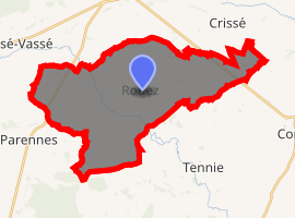
| |
 Rouez-en-Champagne  Rouez-en-Champagne | |
| Coordinates: 48°08′25″N 0°06′46″W | |
| Country | France |
| Region | Pays de la Loire |
| Department | Sarthe |
| Arrondissement | Mamers |
| Canton | Sillé-le-Guillaume |
| Intercommunality | Champagne Conlinoise et Pays de Sillé |
| Government | |
| • Mayor (2008–2014) | Paul Melot |
| Area 1 | 33.65 km2 (12.99 sq mi) |
| Population (2017-01-01)[1] | 771 |
| • Density | 23/km2 (59/sq mi) |
| Demonym(s) | Rouéziens |
| Time zone | UTC+01:00 (CET) |
| • Summer (DST) | UTC+02:00 (CEST) |
| INSEE/Postal code | 72256 /72140 |
| Elevation | 92–171 m (302–561 ft) |
| 1 French Land Register data, which excludes lakes, ponds, glaciers > 1 km2 (0.386 sq mi or 247 acres) and river estuaries. | |
Geography
The village lies in the middle of the commune, on the left bank of the Merdereau, a left tributary of the Vègre, which flows southeastward through the commune.
gollark: Most of the high-power stuff like that is task-specific and only really usable for multiplying big matrices by vectors, and such.
gollark: It would be nontrivial to make something render SVGs on so much computing power without ridiculous overhead/waste.
gollark: Well, according to estimates, my brain would require about an exaflop/s of computing power to run.
gollark: > It is similar in concept to SVG (Scalable Vector Graphics) but much simpler. Compared to SVG Tiny, which isn't actually tiny, it does not have features for text, multimedia, interactivity, linking, scripting, animation, XSLT, DOM, combination with raster graphics such as JPEG formatted textures, etc.
gollark: https://github.com/google/iconvg is a similar thing.
See also
References
- "Populations légales 2017". INSEE. Retrieved 6 January 2020.
| Wikimedia Commons has media related to Rouez. |
| Authority control |
|
|---|
This article is issued from Wikipedia. The text is licensed under Creative Commons - Attribution - Sharealike. Additional terms may apply for the media files.