Rodolivos
Rodolivos (Greek: Ροδoλίβος) is a town and a former municipality in the Serres regional unit, Greece. Since the 2011 local government reform it is part of the municipality Amfipoli, of which it is the seat and a municipal unit.[2] The municipal unit has an area of 106.034 km2.[3] It is about 30 km from Drama. Its population was 2,611 in 2001. The village is at the foot of Mount Pangaio.
Rodolivos Ροδoλίβος | |
|---|---|
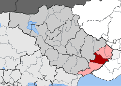
 Rodolivos Location within the regional unit  | |
| Coordinates: 40°55′N 23°58′E | |
| Country | Greece |
| Administrative region | Central Macedonia |
| Regional unit | Serres |
| Municipality | Amfipoli |
| • Municipal unit | 106.0 km2 (40.9 sq mi) |
| Population (2011)[1] | |
| • Municipal unit | 2,611 |
| • Municipal unit density | 25/km2 (64/sq mi) |
| Community | |
| • Population | 2,072 (2011) |
| Time zone | UTC+2 (EET) |
| • Summer (DST) | UTC+3 (EEST) |
| Vehicle registration | ΕΡ |
Just next to Rodolivos, namely on the hill of "St. Athanasius" and also in the neighboring place "Kouria", are attested traces of two ancient settlements of Edonida (Greek: Ηδωνίδα), which were located on the via Egnatia.[4]In these sites were found some inscriptions of imperial times (2nd-3rd AD).[5]
Subdivisions
The municipal unit Rodolivos is subdivided into the following communities (population in 2011 in square brackets):
- Rodolivos [ 2072 ]
- Domiros [ 154 ]
- Mikro Souli [ 385 ]
References
- "Απογραφή Πληθυσμού - Κατοικιών 2011. ΜΟΝΙΜΟΣ Πληθυσμός" (in Greek). Hellenic Statistical Authority.
- Kallikratis law Greece Ministry of Interior (in Greek)
- "Population & housing census 2001 (incl. area and average elevation)" (PDF) (in Greek). National Statistical Service of Greece.
- D. C. Samsaris, Historical Geography of Eastern Macedonia during the Antiquity (in Greek), Thessaloniki 1976 (Society for Macedonian Studies), p. 186-187. ISBN 960-7265-16-5.
- D. C. Samsaris, La vallée du Bas-Strymon á l’ époque impériale (Contribution épigraphique á la topographie, l’ onomastique, l’ histoire et aux cultes de la province romaine de Macédoine), Dodona 18 (1989), fasc. 1, p. 294-295, n. 153-156 = The Packard Humanities Institute (Samsaris, Bas-Strymon 153, # PH150794) The Packard Humanities Institute (Samsaris, Bas-Strymon 154, # PH150795)The Packard Humanities Institute (Samsaris, Bas-Strymon 155, # PH150796) The Packard Humanities Institute (Samsaris, Bas-Strymon 156, # PH150797)