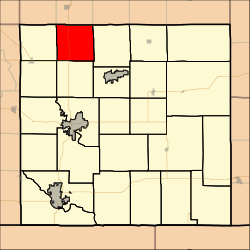
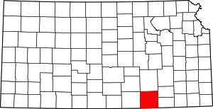
Rock Creek Township, Cowley County, Kansas
Rock Creek Township is a township in Cowley County, Kansas, USA. As of the 2000 census, its population was 243.
Rock Creek Township | |
|---|---|
 Location in Cowley County | |
| Coordinates: 37°25′55″N 096°58′16″W | |
| Country | United States |
| State | Kansas |
| County | Cowley |
| Area | |
| • Total | 35.58 sq mi (92.14 km2) |
| • Land | 35.38 sq mi (91.64 km2) |
| • Water | 0.2 sq mi (0.51 km2) 0.55% |
| Elevation | 1,217 ft (371 m) |
| Population (2000) | |
| • Total | 243 |
| • Density | 6.9/sq mi (2.7/km2) |
| GNIS feature ID | 0470020 |
Geography
Rock Creek Township covers an area of 35.58 square miles (92.2 km2) and contains no incorporated settlements. According to the USGS, it contains three cemeteries: Brookshire, Stalter and Widener.
The streams of Durham Creek, Eightmile Creek, Muddy Creek, Myers Creek, Polecat Creek, Rock Creek, Sanford Creek, Spring Creek and Stalter Branch run through this township.
Transportation
Rock Creek Township contains one airport or landing strip, Eaton Acres Landing Strip.
gollark: top
gollark: https://h.osmarks.net/htop/ ← gaze upon HMud resource use in real time
gollark: Oh, ttyd is in the repos, no work for me.
gollark: ... oh no, LibreSSL or something?
gollark: To make Macron, obviously.
This article is issued from Wikipedia. The text is licensed under Creative Commons - Attribution - Sharealike. Additional terms may apply for the media files.
