Riverdale, Kansas
Riverdale is an unincorporated community in Sumner County, Kansas, United States. It is located about 6 miles southwest of Belle Plaine at the intersection of N Sand Plum Rd and 77th Ave N, or west of U.S. Route 81 next to the railroad.[1]
Riverdale, Kansas | |
|---|---|
 1915 Railroad Map of Sumner County | |
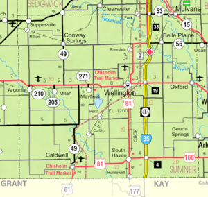 KDOT map of Sumner County (legend) | |
 Riverdale 1915 Railroad Map of Sumner County  Riverdale Riverdale (the United States) | |
| Coordinates: 37°22′20″N 97°23′25″W[1] | |
| Country | United States |
| State | Kansas |
| County | Sumner |
| Elevation | 1,280 ft (390 m) |
| Time zone | UTC-6 (CST) |
| • Summer (DST) | UTC-5 (CDT) |
| FIPS code | 20-60075 |
| GNIS ID | 470163 |
History
A post office was opened in Riverdale in 1887, and remained in operation until it was discontinued in 1973.[2]
A railroad currently passes through the community, north to south, from Wichita to Wellington. Previously a railroad passed through the community, east to west, from Belle Plaine to Conway Springs.
Education
The community is served by Wellington USD 353 public school district.
gollark: I think you're using the wrong definition of backend.
gollark: And there's that one TS compiler in Go (it doesn't check types, just builds things).
gollark: I mean, you need a TS *compiler* of some sort, but your *API server/webserver* doesn't have to be Node.
gollark: Not for sane definitions of "backends".
gollark: For what?
References
- Geographic Names Information System (GNIS) details for Riverdale, Kansas; United States Geological Survey (USGS); October 13, 1978.
- "Kansas Post Offices, 1828-1961, page 2". Kansas Historical Society. Retrieved 27 June 2014.
Further reading
External links
- Sumner County Map, KDOT
Municipalities and communities of Sumner County, Kansas, United States | ||
|---|---|---|
| Cities | 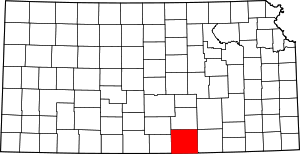 Map of Kansas highlighting Sumner County | |
| CDP | ||
| Unincorporated communities | ||
| Ghost towns |
| |
| Footnotes | ‡This populated place also has portions in an adjacent county or counties | |
This article is issued from Wikipedia. The text is licensed under Creative Commons - Attribution - Sharealike. Additional terms may apply for the media files.