Rila Point
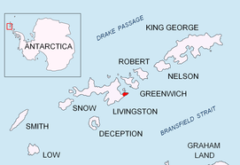
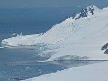
Rila Point (Nos Rila \'nos 'ri-la\) is a low, ice-free point on the south coast of Moon Bay, projecting 330 m west-northwestwards from Burgas Peninsula on Livingston Island in the South Shetland Islands, Antarctica, and forming the east side of the entrance to Bruix Cove. The point is named after Rila Mountain, Bulgaria.

Location of Burgas Peninsula on Livingston Island in the South Shetland Islands.


Topographic map of Livingston Island and Smith Island.
Location
The spit is located at 62°37′12.5″S 59°58′20.5″W, which is 3.2 km northwest of Delchev Peak, 1.93 km east of Yana Point, 9 km south of Edinburgh Hill, 3.51 km southwest of Half Moon Island and 8.61 km west of Renier Point.
Maps
- South Shetland Islands. Scale 1:200000 topographic map No. 3373. DOS 610 – W 62 58. Tolworth, UK, 1968.
- Islas Livingston y Decepción. Mapa topográfico a escala 1:100000. Madrid: Servicio Geográfico del Ejército, 1991.
- S. Soccol, D. Gildea and J. Bath. Livingston Island, Antarctica. Scale 1:100000 satellite map. The Omega Foundation, USA, 2004.
- L.L. Ivanov et al., Antarctica: Livingston Island and Greenwich Island, South Shetland Islands (from English Strait to Morton Strait, with illustrations and ice-cover distribution), 1:100000 scale topographic map, Antarctic Place-names Commission of Bulgaria, Sofia, 2005
- L.L. Ivanov. Antarctica: Livingston Island and Greenwich, Robert, Snow and Smith Islands. Scale 1:120000 topographic map. Troyan: Manfred Wörner Foundation, 2010. ISBN 978-954-92032-9-5 (First edition 2009. ISBN 978-954-92032-6-4)
- Antarctic Digital Database (ADD). Scale 1:250000 topographic map of Antarctica. Scientific Committee on Antarctic Research (SCAR). Since 1993, regularly upgraded and updated.
- L.L. Ivanov. Antarctica: Livingston Island and Smith Island. Scale 1:100000 topographic map. Manfred Wörner Foundation, 2017. ISBN 978-619-90008-3-0
gollark: The other thing, working on refinding the code for it.
gollark: Grid Power is incredibly annoying and useless.
gollark: I don't like ExU's direction or bonuses for its author on servers.
gollark: Yep. mcdex automatically does those.
gollark: So, mod queue now: Redstone Arsenal, maybe Construct's Armory, maybe a TE/TiC integration mod, Ranged Pumps, anything else?
References
- Rila Point. SCAR Composite Antarctic Gazetteer
- Bulgarian Antarctic Gazetteer. Antarctic Place-names Commission. (details in Bulgarian, basic data in English)
External links
- Rila Point. Copernix satellite image
This article includes information from the Antarctic Place-names Commission of Bulgaria which is used with permission.
This article is issued from Wikipedia. The text is licensed under Creative Commons - Attribution - Sharealike. Additional terms may apply for the media files.