Richland Township, Harvey County, Kansas
Richland Township is a township in Harvey County, Kansas, USA. As of the 2000 census, its population was 360.
Richland Township | |
|---|---|
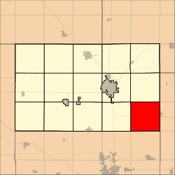 Location in Harvey County | |
| Coordinates: 37°57′20″N 097°12′26″W | |
| Country | United States |
| State | Kansas |
| County | Harvey |
| Area | |
| • Total | 36.34 sq mi (94.11 km2) |
| • Land | 36.27 sq mi (93.93 km2) |
| • Water | 0.07 sq mi (0.19 km2) 0.2% |
| Elevation | 1,411 ft (430 m) |
| Population (2000) | |
| • Total | 360 |
| • Density | 9.9/sq mi (3.8/km2) |
| GNIS feature ID | 0473711 |
| Website | County Website |
Geography
Richland Township covers an area of 36.34 square miles (94.1 km2) and contains the ghost town of Annelly and the southeast corner of the unincorporated community of McLain. According to the USGS, it contains one cemetery, Whitewater. The streams of East Branch Whitewater Creek, West Branch Whitewater Creek and West Wildcat Creek run through this township.
Further reading
gollark: You can't really *do* that.
gollark: Extreme Ultramegasandboxing.
gollark: Maybe I could add it as an optional "PotatOS extreme ultramegasandbox mode".
gollark: I was referring to that. It's been done.
gollark: Yes, but it's very slow and buggy.
References
External links
- Harvey County Website
- City-Data.com
- Harvey County Maps: Current, 1941
Municipalities and communities of Harvey County, Kansas, United States | ||
|---|---|---|
| Cities | 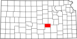 Map of Kansas highlighting Harvey County | |
| Townships | ||
| Unincorporated communities | ||
| Ghost town | ||
| Footnotes | ‡This populated place also has portions in an adjacent county or counties | |
This article is issued from Wikipedia. The text is licensed under Creative Commons - Attribution - Sharealike. Additional terms may apply for the media files.