Republic Airport
Republic Airport (IATA: FRG, ICAO: KFRG, FAA LID: FRG) is a regional airport in East Farmingdale, New York,[2] located one mile east of Farmingdale village limits.[1][3]
Republic Airport | |||||||||||||||
|---|---|---|---|---|---|---|---|---|---|---|---|---|---|---|---|
 Republic Airport | |||||||||||||||
| Summary | |||||||||||||||
| Airport type | Public | ||||||||||||||
| Owner | New York State Department of Transportation | ||||||||||||||
| Serves | Long Island and New York City | ||||||||||||||
| Location | East Farmingdale, New York | ||||||||||||||
| Elevation AMSL | 80 ft / 24 m | ||||||||||||||
| Coordinates | 40°43′44″N 073°24′48″W | ||||||||||||||
| Website | www.republicairport.net | ||||||||||||||
| Maps | |||||||||||||||
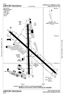
 FAA diagram | |||||||||||||||
 FRG Location of airport in New York / United States  FRG FRG (the United States) | |||||||||||||||
| Runways | |||||||||||||||
| |||||||||||||||
| Statistics (2011) | |||||||||||||||
| |||||||||||||||
The National Plan of Integrated Airport Systems for 2011–2015 categorized it as a general aviation reliever airport.[4] Federal Aviation Administration records say the airport had 3,586 passenger boardings (enplanements) in calendar year 2008,[5] 2,866 in 2009, and 2,783 in 2010.[6]
On behalf of NY State’s Department of Tranportation, the airport is currently managed by AvPORTS, a US-based and owned operator and manager of airports.
History
Republic Airport was developed by Sherman Fairchild as the Fairchild Flying Field in East Farmingdale on Long Island, NY in late 1927 as his flying field and airplane factory on Motor Avenue in South Farmingdale was inadequate to support the mass production of his Fairchild FC-2 and Fairchild 71 airplanes. Fairchild purchased property on the south side of Route 24-Conklin Street and had the airport's original layout plan prepared on November 3, 1927.
The 77.967-acre (315,520 m2) flying field was developed in the late winter and early spring of 1928 and was originally owned and operated by Fairchild Engine & Airplane Manufacturing Company. The first flights from the Fairchild Flying Field took place in late spring of 1928 after the Fairchild Airplane and Airplane Engine factories and hangar were completed and aircraft were produced in the new factories. After Fairchild moved to Hagerstown, Maryland in 1931, Grumman Aircraft Engineering built planes at the airport from 1932 until the spring of 1937.
Seversky Aircraft moved there in January 1935 from College Point in Queens, and became Republic Aviation in 1939. Republic built more than 9,000 P-47 Thunderbolts in Farmingdale during World War II and expanded Republic Field, erected three hangars and a control tower and lengthened and hardened the runways. Republic built the straight-wing F-84 Thunderjet and the swept-wing F-84 Thunderstreak during the Korean War (1952 airport diagram) and extended runway 14-32 to the southeast over the objections of Long Island State Parks Commissioner Robert Moses.
Republic Aviation produced over 800 F-105 Thunderchief fighter bombers during the Vietnam Era. Republic Aviation was acquired by the Fairchild-Hiller Corp. in 1965 for $24.5 million and Fairchild stock. Flight Safety Inc. ran the Republic Airport as a general aviation airport beginning on December 7, 1966 for the Mailman brothers' Farmingdale Corporation, which had purchased the field from Fairchild Hiller for $8 million in 1965.
Republic Airport was acquired by the Metropolitan Transportation Authority (MTA) on March 31, 1969. The MTA installed an instrument landing system (ILS) on runway 14-32, built the Republic Airport Terminal building, cooperated with the Federal Aviation Administration, which built the new 100' high control tower and got the US Government to transfer 94 acres (380,000 m2) to the airport in 1971 and purchased the 77-acre (310,000 m2) Lambert property on the north side of Route 109 and the Breslau Gardens property between New Highway and Route 109 in 1972.
After complaints that the MTA was not contributing taxes to local governments and questions about the MTA spending at Republic, ownership of the airport was transferred to the New York State Department of Transportation (NYSDOT) by the New York State Legislature in April 1983, to promote economic development in the surrounding Long Island region. The Republic Airport Commission was created by the New York State Legislature in 1982 (Chap. 370, L.1982) "as an advisory council to the Commissioner of Transportation in the administration and management of the Republic Airport facilities and its surrounding areas with respect to projects to be undertaken at such airport." Fairchild went out of business in 1987, and much of its historic Fairchild-Republic factory complex was sold and developed as the Airport Plaza shopping mall.
The Long Island Republic Airport Historical Society, formed in 1984, and chartered by the Board of Regents of the State of New York in 1987, maintains sixteen photographic exhibits illustrating the history of aviation, and historical archives, on the first floor of the Republic Airport terminal building behind the FAA tower on the east side of Route 110.
The most recent exhibit illustrates: "The Origins of Airplane Manufacturing in Farmingdale, NY: The Foundation Years: 1917-1928," which documents airplanes built by Lawrence Sperry, Sydney Breese and Sherman Fairchild. The airport is also home to the American Airpower Museum which offers visitors the opportunity to see World War II aircraft in flight.
The airport has seen scheduled passenger airlines: on Cosmopolitan Airlines in the 1980s,[7] Provincetown-Boston Airlines (operating as Continental Express) in the 1980s[8] and Northwest Airlink in the 1990s.[9]
Most NHL teams flying charter flights into Long Island to play the New York Islanders use Republic Airport.
Facilities
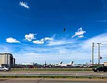
Republic Airport has a two-story terminal building serving passengers boarding charter flights to nearby cities such as Atlantic City, New Jersey. Three fixed based operators serve corporate and light general aviation customers: SheltAir, Republic Jet Center, and Atlantic Aviation. Next to the airport was the 56th Fighter Group restaurant, which closed in August 2012. Also, Troop L of the New York State Police, which covers Nassau and Suffolk Counties, is headquartered at the airport.
The airport covers 526 acres (213 ha) at an elevation of 80 feet (24 m). It has two asphalt runways: 14/32 is 6,833 by 150 feet (2,083 x 46 m) and 1/19 is 5,516 by 150 feet (1,681 x 46 m).[1] In 2011 the airport had 188,642 aircraft operations, average 516 per day: 95% general aviation, 5% air taxi, <1% military, and <1% airline. 508 aircraft were then based at this airport: 72% single-engine, 15% multi-engine, 9% jet, and 5% helicopter.[1]
Charter airlines
| Airlines | Destinations |
|---|---|
| Dee Casino Tours | Seasonal charter: Atlantic City |
| Justice Air Charter | Luxury charter; any location |
| Talon Air, Inc. | Charter; any location |
See also
- Transportation in New York City
- List of airports in New York
- New York World War II Army airfields
References
![]()
- FAA Airport Master Record for FRG (Form 5010 PDF). Federal Aviation Administration. Effective November 15, 2012.
- Bleyer, Bill. "List of Geographical Misnomers". Newsday. Archived from the original on May 28, 2006. Retrieved September 11, 2007.
- "Map show airport, Farmingdale, East Farmingdale, and county border of Nassau and Suffolk". MapQuest. Retrieved June 17, 2013.
-
"2011–2015 NPIAS Report, Appendix A" (PDF, 2.03 MB). National Plan of Integrated Airport Systems. Federal Aviation Administration. October 4, 2010. External link in
|work=(help) -
"Enplanements for CY 2008" (PDF, 1.0 MB). CY 2008 Passenger Boarding and All-Cargo Data. Federal Aviation Administration. December 18, 2009. External link in
|work=(help) -
"Enplanements for CY 2010" (PDF, 189 KB). CY 2010 Passenger Boarding and All-Cargo Data. Federal Aviation Administration. October 4, 2011. External link in
|work=(help) - "Cosmopolitan Airlines". Retrieved 26 April 2016.
- "CO020187p17". Retrieved 26 April 2016.
- Study of Future Use: Republic Airport. State of New York, Office of the State Comptroller. February 10, 1999.
External links
- Republic Airport, official site
- American Airpower Museum
- "Hundreds Attend Meeting on Republic Airport". Farmingdale Observer. August 18, 2000.
- Republic Airport (FRG) at NYSDOT Airport Directory
- Aerial image as of April 1994 from USGS The National Map
- FAA Airport Diagram (PDF), effective July 16, 2020
- FAA Terminal Procedures for FRG, effective July 16, 2020
- Resources for this airport:
- FAA airport information for FRG
- AirNav airport information for KFRG
- ASN accident history for FRG
- FlightAware airport information and live flight tracker
- NOAA/NWS weather observations: current, past three days
- SkyVector aeronautical chart, Terminal Procedures