Reisseck Railway
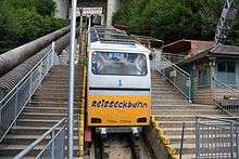
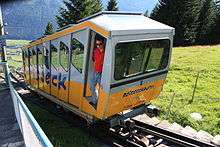
The Reisseck Railway (sometimes Reißeck Railway, German: Reißeckbahn) is a mountain railway, that runs from Carinthia's Möll valley into the Reißeck Group, a small mountain range in southern Austria. It comprises the Reisseck Funicular and the Reisseck Mountain Railway (a narrow gauge railway).
General
The Reisseck Railway starts in Kolbnitz in the Möll valley at a height of 719 m (AA) and ends for passenger services at the Berghotel Reisseck at a height of 2,250 m above sea level (AA) Further sections of line end at about 2,400 m. On the opposite side of the valley is another funicular, the Kreuzeck Railway. The lines are operated by Tauern Touristik.
Originally the railway was built to transport materiel to the dam and power station of the Reisseck-Kreuzeck power station. After various modifications and expansions its main function today is to provide passenger services.
The railway is closed in 2016 during construction work at Schoberboden.
Reisseck Funicular
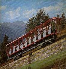
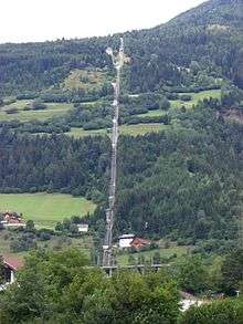
The Reisseck Funicular is a metre-gauge line and consists of 3 sections with a total length of around 3,500 metres. It climbs through 1,517 metres in height. The highest station is at 2,236 m by the Schoberboden. Next to the funicular is a pipe, 4,234.5 metres long, that carries water from the lakes of Großer Mühldorfer See, Kleiner Mühldorfer See, Hochalmsee and Radlsee into the Möll valley to the Reisseck-Kreuzeck storage reservoir.
Each section of the line is worked by coaches with 64 seats that are hauled by 40-millimetre-thick cables from their upper stations. The diameter of the electrically driven cable drums is 3.85 metres. The gradient of the line varies between 25 and 82%.
| Kilo- metrage | Height m | Station or stop | Remarks | Location |
|---|---|---|---|---|
| 0.0 | 719 | Zandlach | Bottom station | Zandlach 46°52′48.17″N 13°18′58.43″E |
| 1.185 | 1.270 | Schütter | Connection between sections 1 and 2 | 46°53′18.42″N 13°19′7.42″E |
| 2.475 | 1.749 | Trog | Connection between sections 2 and 3 | 46°53′49.86″N 13°19′27.85″E |
| 3.650 | 2.236 | Schoberboden | Connection between sections 3 and the Reisseck Mountain Railway | 46°54′12.96″N 13°20′0.43″E |
| Section | Length km | Height difference | Average gradient | Maximum gradient |
|---|---|---|---|---|
| Zandlach – Schütter | 1.185 | 551 m | 55 % | 82 % |
| Schütter – Trog | 1.290 | 479 m | 51 % | 74 % |
| Trog – Schoberboden | 1.130 | 487 m | 49 % | 76 % |
External links
| Wikimedia Commons has media related to Reisseck Railway. |
- Reisseck railways on the Verbund site
- Reisseck mountain railways
- Informationen auf der Village home page
- Photographs of the railway
| Current |
| |
|---|---|---|
| Defunct |
| |