Reddingen
Reddingen is a village in the municipality of Wietzendorf in Soltau-Fallingbostel district, Lower Saxony, Germany. The village, even with its associated hamlets of Reiningen and Halmern, only has 100 inhabitants.
Reddingen | |
|---|---|
Ortsteil of Wietzendorf | |
Location of Reddingen 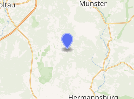
| |
 Reddingen 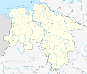 Reddingen | |
| Coordinates: 52°54′41.29″N 10°00′52.46″E | |
| Country | Germany |
| State | Lower Saxony |
| District | Soltau-Fallingbostel |
| Town | Wietzendorf |
| Elevation | 72 m (236 ft) |
| Population (2008-07-01) | |
| • Total | 100 |
| Time zone | CET/CEST (UTC+1/+2) |
| Postal codes | 29649 |
| Dialling codes | 05196 |
Location
Reddingen lies on the Lüneburg Heath. The Wietze river flows through the settlement of Reiningen. The Munster South Training Area begins immediately north of the three villages and is closed to the public.
Transport
The K 11 and K 38 district roads meet in the village. The VNN's bus line no. 352 runs through the villages.
By the Wietze in Reiningen is a water gauge and a hydrometric gauging station belonging to the NLWKN for gathering environmental data.
In Halmern, Reddingen and Reiningen there are no road names, just house numbers which the residents, postal staff, local suppliers and visitors have to get to know.
Politics
The chair of the parish council (Ortsvorsteher) is Wilhelm Grünhagen.
.jpg) Reed-covered house in Reiningen, workshop for hand-made dolls
Reed-covered house in Reiningen, workshop for hand-made dolls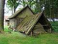 Historic clay oven in Reiningen
.jpg) Old Treppenspeicher in Reiningen
Old Treppenspeicher in Reiningen.jpg) The Wietze in Reiningen
The Wietze in Reiningen
Villages in the municipality of Wietzendorf | ||
|---|---|---|
| ||