Reddigudem mandal
Reddigudem mandal is one of the 50 mandals in the Krishna district of the Indian state of Andhra Pradesh.[1]
Reddigudem Mandal | |
|---|---|
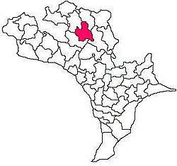 Mandal map of Krishna district showing Reddigudem mandal (in Rose Colour) | |
.svg.png) Reddigudem Mandal Location in Andhra Pradesh, India | |
| Coordinates: 16.8690°N 80.7367°E | |
| Country | India |
| State | Andhra Pradesh |
| District | Krishna |
| Headquarters | Reddigudem |
| Government | |
| • Body | Mandal Parishad |
| Area | |
| • Total | 89.73 km2 (34.64 sq mi) |
| Population (2011) | |
| • Total | 53,540 |
| • Density | 600/km2 (1,500/sq mi) |
| Languages | |
| • Official | Telugu |
| Time zone | UTC+5:30 (IST) |
| PIN | 521 XXX |
| Vehicle registration | AP 16 |
Villages
- Anneraopeta
- Kudapa
- Kunaparajuparva
- Maddulaparva
- Mutchinapalle
- Naguluru
- Narukullapadu
- Patha Naguluru
- Rangapuram
- Reddigudem
- Raghavapuram
- Rudravara
gollark: You could get the same hard-to-brute-force-ness with, apparently, a 37 digit base 10 one.
gollark: It's basically just a convoluted way to express a 60-digit base-4 number.
gollark: The important thing is how much y increases each time x goes up by 1, which is the gradient.
gollark: I think so, yes. Generally I would take the equation (y = 3x + c) and substitute in one of the points' x and y values, but I guess for this that works.
gollark: You have the value when x = 1.
This article is issued from Wikipedia. The text is licensed under Creative Commons - Attribution - Sharealike. Additional terms may apply for the media files.