Rawley Springs, Virginia
Rawley Springs is an unincorporated community located in Rockingham County, in the U.S. state of Virginia. It is located nine miles west of Harrisonburg, north of Clover Hill, along U.S. Route 33, near the George Washington National Forest.[1][2] It lies on the Dry River and is situated on the southern slope of the North Mountain.[1]
Rawley Springs | |
|---|---|
Unincorporated community | |
 Rawley Springs Location in Virginia  Rawley Springs Rawley Springs (the United States) | |
| Coordinates: 38°30′37″N 79°2′57″W | |
| Country | |
| State | Virginia |
| County | Rockingham County |
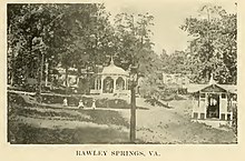
Rawley Springs, Virginia, circa 1909
References
- Moorman, John Jennings (1859). The Virginia springs, and springs of the South and West. J.B. Lippincott & co. p. 298. Retrieved 26 January 2011.
- Google Maps (Map). Google.
| Wikimedia Commons has media related to Rawley Springs, Virginia. |
Municipalities and communities of Rockingham County, Virginia, United States | ||
|---|---|---|
| Towns | 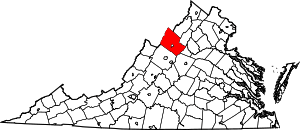 Map of Virginia highlighting Rockingham County | |
| CDPs | ||
| Unincorporated communities |
| |
| Footnotes | ‡This populated place also has portions in an adjacent county or counties | |
This article is issued from Wikipedia. The text is licensed under Creative Commons - Attribution - Sharealike. Additional terms may apply for the media files.