Ravne v Bohinju
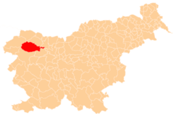
Ravne v Bohinju (pronounced [ˈɾaːu̯nɛ w bɔˈxiːnju]) is a settlement in the Municipality of Bohinj in the Upper Carniola region of Slovenia. It includes the hamlets of Spodnji Konec, Zgornji Konec, and Dolino.[2]
Ravne v Bohinju | |
|---|---|
 Ravne v Bohinju Location in Slovenia | |
| Coordinates: 46°15′33.19″N 13°57′51.23″E | |
| Country | |
| Traditional region | Upper Carniola |
| Statistical region | Upper Carniola |
| Municipality | Bohinj |
| Elevation | 731.6 m (2,400.3 ft) |
| Population (2002) | |
| • Total | 51 |
| [1] | |
Geography
Ravne v Bohinju lies on a sloping mountain terrace above the railroad tunnel south of Bohinjska Bistrica. The village has a road connection to Bohinjska Bistrica, and the road continues west from the village into the foothills of the Komna Plateau. There are three springs in the village: one at the Pavle Clearing (Pavletov rovt) in Spodnji Konec, one at the Balant Commons (Balantova gmjana) in Zgornji Konec, and one at the Klemenc Commons (Klemenčeva gmajna) in Dolino.[2]
Name
The name of the settlement was changed from Ravne to Ravne v Bohinju in 1955.[3]
History
Cheese-making and dairy activity were formerly important economic activities in Ravne v Bohinju. Cheese-making was abandoned soon after the Second World War and the dairy industry went into decline.[2]
Mass grave
Ravne v Bohinju is the site of a mass grave from the Second World War. The Jate Shaft Mass Grave (Slovene: Grobišče Brezno na Jatah) is located in the woods southwest of the settlement, at a site where water collects and flows into a cave during heavy rain. The shaft contains the remains of two people thrown into the cave during the war.[4]
References
- Statistical Office of the Republic of Slovenia
- Savnik, Roman (1968). Krajevni leksikon Slovenije, vol. 1. Ljubljana: Državna založba Slovenije. p. 288.
- Spremembe naselij 1948–95. 1996. Database. Ljubljana: Geografski inštitut ZRC SAZU, DZS.
- Ferenc, Mitja (December 2009). "Grobišče Brezno na Jatah". Geopedia (in Slovenian). Ljubljana: Služba za vojna grobišča, Ministrstvo za delo, družino in socialne zadeve. Retrieved April 29, 2020.
