Ranikhet district
Ranikhet District is newly proposed district to split Almora district in the state of Uttarakhand, India.[1] Its area is 1397 km2 and population is 322,408[1]
Ranikhet District | |
|---|---|
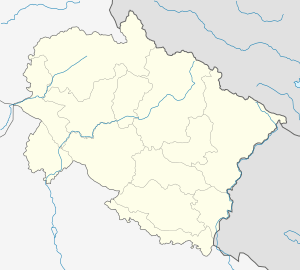 Ranikhet District Location in Uttarakhand, India  Ranikhet District Ranikhet District (India) | |
| Coordinates: 29.65°N 79.42°E | |
| Country | |
| State | Uttarakhand |
| District | Ranikhet |
| Population | |
| • Total | 322,408 |
| Languages | |
| • Official | Hindi |
| • Regional | Kumaoni |
| Time zone | UTC+5:30 (IST) |
| Vehicle registration | UK |
| Website | uk |
Blocks
- Eight
Visiting places
Ranikhet is a hill station.
Religious places
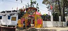
Jhula Devi Temple, Ranikhet
- Jhula Devi Temple
gollark: Also, by spec size TOML is far easier than YAML.
gollark: JSON lacks comments deliberately because people were using them to add parsing directives.
gollark: Also HJSON/JSON5 for comments.
gollark: <@271274710753476610> SQLite!
gollark: If you like heavpoot's page try my talk page: https://esolangs.org/wiki/User_talk:Osmarks
References
- "मानक शिथिल कर उत्तराखंड में चार नए जिलों की संस्तुति". Jagran.com. Retrieved 14 August 2018.
This article is issued from Wikipedia. The text is licensed under Creative Commons - Attribution - Sharealike. Additional terms may apply for the media files.