Rajčanka
Rajčanka or Rajčianka (Hungarian: Rajcsánka) is a river in northern Slovakia springing in Strážovské vrchy near Čičmany and pouring into Váh in Žilina. It is 46.6 km (29.0 mi) long and its basin size is 359 km2 (139 sq mi).[1]
| Rajčanka | |
|---|---|
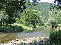 River near Porúbka | |
| Physical characteristics | |
| Source | |
| • location | Strážovské vrchy |
| Mouth | |
• location | Váh in Žilina |
• coordinates | 49.2352°N 18.7085°E |
| Length | 46.6 km (29.0 mi) |
| Basin size | 359 km2 (139 sq mi) |
| Basin features | |
| Progression | Váh→ Danube→ Black Sea |
It forms the border of Lúčanská Malá Fatra Mountains and of Strážovské vrchy. 32 km of its length are navigable.
Cities along its course are: Rajec, Rajecké Teplice, Žilina.
Names and etymology
The original name of the river was Lietava, later Žilinka and only after the founding of Rajec (the 14th century) also Rajčanka[2] (see also Etymology of Rajec).
gollark: tio!help
gollark: tio!debug
gollark: ```c#define let int#include <stdlib.h>let main() { for (let i = 0; i < 10000; i++) { free(malloc(i)); }}```
gollark: tio!debug
gollark: ```c#define let int#include <stdlib.h>let main() { for (let i = 0; i < 10000; i++) { free(malloc(5)); }}```
References
- Plán manažmentu povodňového rizikavčiastkovom povodí Váhu, p. 72
- Krško, Jaromír (2011). Hydronymia horného povodia Váhu [Hydronymy of the Upper Váh Basin] (in Slovak). Banská Bystrica: Univerzita Mateja Bela. p. 125.
This article is issued from Wikipedia. The text is licensed under Creative Commons - Attribution - Sharealike. Additional terms may apply for the media files.