Raipur, Uttarakhand
Raipur is a census town in Dehradun district in the Indian state of Uttarakhand.
Raipur | |
|---|---|
City | |
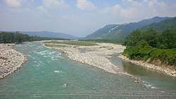 Song River flowing through Raipur, Uttarakhand | |
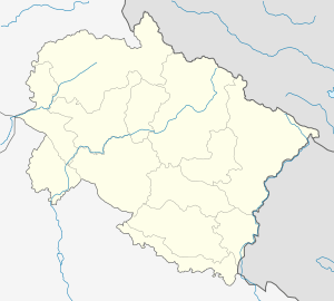 Raipur Location in Uttarakhand, India  Raipur Raipur (India) | |
| Coordinates: 30.306°N 78.098°E | |
| Country | |
| State | Uttarakhand |
| District | Dehradun |
| Elevation | 483 m (1,585 ft) |
| Population (2011) | |
| • Total | 32,900 |
| Languages | |
| • Official | Hindi |
| Time zone | UTC+5:30 (IST) |
| PIN | 248008 |
| Telephone code | 0135 |
| Vehicle registration | UK-07 |
| Website | uk |
Geography
Raipur is located at 30.306°N 78.098°E. It has an average elevation of 663 metres (2,175 feet).
Demographics
As of the 2001 India census,[1] Raipur had a population of 24,887. Males constitute 52% of the population, and females constitute 48%. Raipur has an average literacy rate of 81%, higher than the national average of 59.5%. Male literacy is 85%, and female literacy is 78%. In Raipur, 11% of the population is under 6 years of age.
gollark: This is a funny and yet vaguely horrifying consequence of several problems in my code and the design of email.
gollark: Oh, this is a cool idea.
gollark: Also draconium.
gollark: No, you need *clay* for balance.
gollark: For technical reasons, I use their account.#
References
- "Census of India 2001: Data from the 2001 Census, including cities, villages and towns (Provisional)". Census Commission of India. Archived from the original on 16 June 2004. Retrieved 1 November 2008.
This article is issued from Wikipedia. The text is licensed under Creative Commons - Attribution - Sharealike. Additional terms may apply for the media files.