Račeva
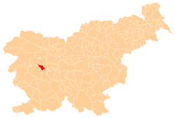
Račeva (pronounced [ˈɾaːtʃɛʋa]) is a dispersed settlement in a valley of the same name southeast of Žiri in the Upper Carniola region of Slovenia. Račeva Creek runs along the valley and is a tributary of the Poljane Sora River (Slovene: Poljanska Sora).[2]
Račeva | |
|---|---|
 Račeva Location in Slovenia | |
| Coordinates: 46°2′0.26″N 14°8′29.14″E | |
| Country | |
| Traditional region | Upper Carniola |
| Statistical region | Upper Carniola |
| Municipality | Žiri |
| Area | |
| • Total | 3.22 km2 (1.24 sq mi) |
| Elevation | 528.8 m (1,734.9 ft) |
| Population (2002) | |
| • Total | 159 |
| [1] | |
History
During the Second World War, the border between territory annexed to Nazi Germany and Fascist Italy ran along Račeva Creek. In 1941, the Germans demolished the water-powered Debenc Mill during demarcation of the border.[3]
gollark: And practicality somewhat.
gollark: Yes it does. I program for funlolz.
gollark: Rob Pike even attacked *syntax highlighting* for being childish.
gollark: I mean, they're gaining generics *now*, very late, but they just have this apious attitude of disregarding every development in computing in the last 50 years and claiming it's because programmers can't be trusted to use them right.
gollark: lol no generics
References
- Statistical Office of the Republic of Slovenia
- Žiri municipal site
- Savnik, Roman (1968). Krajevni leksikon Slovenije, vol. 1. Ljubljana: Državna založba Slovenije. p. 184.
This article is issued from Wikipedia. The text is licensed under Creative Commons - Attribution - Sharealike. Additional terms may apply for the media files.
