Punchbowl Formation
The Punchbowl Formation is a sedimentary sandstone geologic formation in the northern San Gabriel Mountains, above the Antelope Valley in Los Angeles County, southern California.[2][3]
| Punchbowl Formation Stratigraphic range: Neogene | |
|---|---|
 | |
| Type | Formation |
| Underlies | Crowder Formation[1] |
| Location | |
| Region | San Gabriel Mountains, Los Angeles County, California |
| Country | United States |
Geology

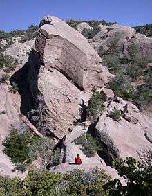
The formation's sandstone strata are seen in the walls of the Devil's Punchbowl, a scenic gorge within the Devil's Punchbowl Natural Area, an L.A. County park within the Angeles National Forest. Three separate faults have folded and uplifted the formation in view.[2] The Devil's Punchbowl is a large plunging sandstone syncline, where the edges of the formation have been folded upward, and the center has dipped. It was formed by the Punchbowl Fault, which is near the San Andreas Fault to the north.
The uplifted formation preserves fossils dating back to the Neogene period of the Cenozoic geologic era, formed during the lower Pliocene to upper Miocene Ages (~5-10 million years ago).[2][4]
The Devil's Punchbowl drainage flows into Sandrock Creek, a tributary of Big Rock Creek, which disappears into the Mojave Desert.[2]
See also
- List of fossiliferous stratigraphic units in California
- Neogene period in California
- Paleontology in California
References
- Thomas Dibblee (1967), "Areal geology of the western Mojave Desert, California", Professional Paper, 522: 49, doi:10.3133/PP522, Wikidata Q57842316
- UCB−Seismo.berkeley.edu: Field Guide to the Punchbowl Fault Zone at the Devil's Punchbowl Natural Area . accessed 7.7.2015
- Various Contributors to the Paleobiology Database. "Fossilworks: Gateway to the Paleobiology Database". Archived from the original on 31 July 2014. Retrieved 8 July 2014.
- L.A. County: "Geological History", with images.
External links
- Los Angeles County: Devil's Punchbowl Natural Area website
- Devil's Punchbowl photos gallery — geology + flora.
| Wikimedia Commons has media related to Punchbowl Formation. |