Pramanta
Pramanta (Greek: Πράμαντα) is a village and a former municipality in the Ioannina regional unit, Epirus, Greece. Since the 2011 local government reform it is part of the municipality North Tzoumerka, of which it is a municipal unit.[2] In 2011 its population was 1,137 for the town, 1,527 for the community and 1,774 for the municipal unit. The municipal unit has an area of 69.058 km2, the community 39.435 km2.[3] Pramanta is situated in the Athamanika mountains, at about 840m elevation. It is 4 km west of Melissourgoi, 6 km north of Agnanta, 6 km south of Prosilio, 65 km southeast of Ioannina, 70km north east of Arta and 28 km south of Metsovo.
Pramanta Πράμαντα | |
|---|---|
 Pramanta Location within the regional unit 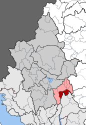 | |
| Coordinates: 39°31′N 21°06′E | |
| Country | Greece |
| Administrative region | Epirus |
| Regional unit | Ioannina |
| Municipality | North Tzoumerka |
| • Municipal unit | 69.058 km2 (26.663 sq mi) |
| Population (2011)[1] | |
| • Municipal unit | 1,774 |
| • Municipal unit density | 26/km2 (67/sq mi) |
| Community | |
| • Population | 1,527 (2011) |
| • Area (km2) | 39.435 |
| Time zone | UTC+2 (EET) |
| • Summer (DST) | UTC+3 (EEST) |
| Vehicle registration | ΙΝ |
Subdivisions
The municipal unit Pramanta is subdivided into the following communities (constituent villages in brackets):
- Ampelochori
- Pramanta (Pramanta, Tsopela, Christoi)
- Raftanaioi (Raftanaioi, Vounoreia, Zalouchos, Megali Rachi, Mylokopeio, Palaiomochousti, Pallikari, Plaka, Rouga, Fraxos)
Population
| Year | Village population | Municipal district population | Municipality population |
|---|---|---|---|
| 1981 | - | 1,585 | - |
| 1991 | 1,090 | 1,708 | - |
| 2001 | 1,422 | 1,845 | 2,194 |
| 2011 | 1,137 | 1,527 | 1,774 |
Attractions
In the central square one can view the known perennial plane tree, the historic fountain called "Arapis" and the central church of the village, Agia Paraskevi. Close to Pramanta is a cave, "Anemotrypa", and the mountain retreat in the place "Isioma".
References
- "Απογραφή Πληθυσμού - Κατοικιών 2011. ΜΟΝΙΜΟΣ Πληθυσμός" (in Greek). Hellenic Statistical Authority.
- Kallikratis law Greece Ministry of Interior (in Greek)
- "Population & housing census 2001 (incl. area and average elevation)" (PDF) (in Greek). National Statistical Service of Greece.
Places adjacent to Pramanta | |
|---|---|