Prüm (river)
The Prüm (German pronunciation: [ˈpʁʏm]) is a river in Rhineland-Palatinate, Germany, left tributary of the Sauer.
| Prüm | |
|---|---|
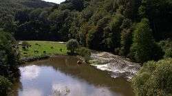 The Prüm near Waxweiler | |
.png) Course of the Prüm | |
| Location | |
| Location | Eifel, Vulkaneifel, Bitburg-Prüm, Rhineland-Palatinate, Germany |
| Reference no. | DE: 2628 |
| Physical characteristics | |
| Source | |
| • location | Between Ormont and Reuth on the Schneifelridge |
| • coordinates | 50°18′53″N 6°28′8.8″E |
| • elevation | ca. 650 m above sea level (NHN) |
| Mouth | |
• location | in Minden into the Sauer |
• coordinates | 49°49′22″N 6°28′16.1″E |
• elevation | ca. 154 m above sea level (NHN) |
| Length | 95.04 km (59.06 mi)[1] |
| Basin size | 888.758 km2 (343.151 sq mi)[1] |
| Discharge | |
| • location | at its mouth[2] |
| • average | 11.42 m³/s |
| Basin features | |
| Progression | Sauer→ Moselle→ Rhine→ North Sea |
| Landmarks |
|
| Tributaries | |
| • left | Nims |
| • right | Enz |
| Waterbodies | Reservoirs: Bitburg Reservoir |
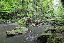 The Prüm between Prümzurlay and Irrel | |
Its total length is 95 km (59 mi), and its basin area is 889 km2 (343 sq mi).[3] The Prüm rises in the Schneifel hills, north of the town of Prüm, close to the border with Belgium. It flows southward through Prüm, Waxweiler, Holsthum, and Irrel. The Prüm discharges to the Sauer in Minden, on the border with Luxembourg, three kilometres east of Echternach. The largest tributary of the Prüm is the Nims.
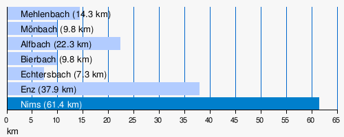
Catchment and tributaries
The catchment of the Prüm is 888.758 km2 (343.151 sq mi)[1] in area. The largest tributaries of the Prüm are (l = left bank (dark blue), r = right bank (light blue)):
- Mehlenbach (r), 14.3 km (8.9 mi), before Watzerath
- Mönbach (r), 9.8 km (6.1 mi), after Watzerath
- Alfbach (r), 22.3 km (13.9 mi), near Pronsfeld
- Bierbach (r), 9.8 km (6.1 mi), after Pronsfeld
- Echtersbach (r), 7.3 km (4.5 mi), before Brecht
- Enz (r), 37.9 km (23.5 mi), in Holsthum
- Nims (l), 61.4 km (38.2 mi), at Irrel
gollark: Maybe I should build a more powerful reactor.
gollark: The problem now is nicely processing them.
gollark: Good to see trading working, though the quarry is likely to wreck that.
gollark: Or `swing`.
gollark: Equip it and use its `use` method.
References
- Geoexplorer of the Rhineland-Palatinate Water Authority (Wasserwirtschaftsverwaltung Rheinland-Pfalz)
- Combined gauge data from Prümzurlay on the Prüm and Alsdorf-Oberecken on its confluence with the Nims, increased by the remaining catchment area (51.2 km²) with a (low estimate) Mq of 10 l/s km²
- Geoportal Rheinland-Pfalz
This article is issued from Wikipedia. The text is licensed under Creative Commons - Attribution - Sharealike. Additional terms may apply for the media files.