Pothumarru
Pothumarru is a village in Kalidindi mandal, located in Krishna district of the Indian state of Andhra Pradesh.[1]
Pothumarru | |
|---|---|
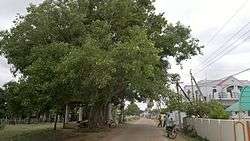 A 300-year-old Holy Fig tree Pothumarru
village Pothumarru rajus also known as namburi rajus were one of the richest families in india during 1800s and 1900s British india. | |
.svg.png) Pothumarru Location in Andhra Pradesh, India  Pothumarru Pothumarru (India) | |
| Coordinates: 16°1′11″N 80°55′12″E | |
| Country | India |
| State | Andhra Pradesh |
| District | Krishna |
| Government | |
| • Type | Democratic |
| • Body | Panchayatraj |
| Area | |
| • Total | 10.15 km2 (3.92 sq mi) |
| Elevation | 57 m (187 ft) |
| Population (2011)[1] | |
| • Total | 3,781 |
| • Density | 370/km2 (960/sq mi) |
| Languages | |
| • Official | Telugu |
| Time zone | UTC+5:30 (IST) |
| Area code(s) | +91-8671 |
| Vehicle registration | AP |
| Lok Sabha constituency | Machilipatnam |
Geography
Pothumarru is located at 16°31'46"N 81°18'46"E.
gollark: ?
gollark: Why would gnobody use it
gollark: What anonymous messaging?
gollark: wasm-4.
gollark: I assume cool people are perceiving them with good™ senses.
References
- "District Census Handbook - Krishna" (PDF). Census of India. p. 16,352. Retrieved 14 February 2016.
This article is issued from Wikipedia. The text is licensed under Creative Commons - Attribution - Sharealike. Additional terms may apply for the media files.