Porter Brook
The Porter Brook is a river in the City of Sheffield, England descending over 1,000 feet (300 m) from its source among the sedge grass on Burbage moor behind a small farm on Hangram just inside the Peak District National Park in the west of the city at Clough Hollow, near the village of Ringinglow. Porter Brook derives its name from its brownish colour, similar to the colour of Porter, a brownish discolouration obtained as it passes over iron-ore deposits on its course from the source. Close to the source, at the junction of Fulwood Lane and Greenhouse Lane is a Rotary Club funded toposcope, Finder Cairn.[1][2]
| Porter Brook | |
|---|---|
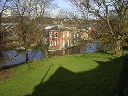 The Porter Brook at Wilson's Sharrow Mill. | |
| Location | |
| Country | England |
| Physical characteristics | |
| Source | |
| • location | Pennines |
| Length | 6.5 mi (10.5 km) |
From here it flows eastward through Porter Clough through Mayfield Valley to the first of the remaining mill dams. Beyond Forge Dam, where the Porter is defined as a main river, the brook makes its way through Endcliffe Park to Hunter's Bar, before running between Ecclesall Road and Sheffield General Cemetery, past the former Wards brewery.[3] The section of the river from Renton Street, near to the location of Sharrow Forge (No. 15), is now built over running through culverts beneath the intersection of London Road and Eyre Street. It re-emerges by Eyre Street after which it flows alongside Mary Street, beneath the bridge on Matilda Street, through the new Matilda Street Pocket Park and behind the BBC offices on Shoreham Street, passing beneath Leadmill Road towards the culvert at Cross Turner Street outside Sheffield Station. It meets the River Sheaf in tunnels beneath the Station, under Platform 5a.[4] The Sheaf & Porter Rivers Trust intent to replace the wooden access cover on the platform which is directly above the confluence with a steel grating cover, allowing the public to look down into the river and also provide an information board.
Water power
Porter Brook | ||||||||||||||||||||||||||||||||||||||||||||||||||||||||||||||||||||||||||||||||||||||||||||||||||||||||||||||||||||||||||||||||||||||||||||||||||||||||||||||||||||||||||||||||||||||||||||||||||||||||||||||||||||||||||||||||||||||||||||||||||||||||||||||||||||||||||||||||||||||||
|---|---|---|---|---|---|---|---|---|---|---|---|---|---|---|---|---|---|---|---|---|---|---|---|---|---|---|---|---|---|---|---|---|---|---|---|---|---|---|---|---|---|---|---|---|---|---|---|---|---|---|---|---|---|---|---|---|---|---|---|---|---|---|---|---|---|---|---|---|---|---|---|---|---|---|---|---|---|---|---|---|---|---|---|---|---|---|---|---|---|---|---|---|---|---|---|---|---|---|---|---|---|---|---|---|---|---|---|---|---|---|---|---|---|---|---|---|---|---|---|---|---|---|---|---|---|---|---|---|---|---|---|---|---|---|---|---|---|---|---|---|---|---|---|---|---|---|---|---|---|---|---|---|---|---|---|---|---|---|---|---|---|---|---|---|---|---|---|---|---|---|---|---|---|---|---|---|---|---|---|---|---|---|---|---|---|---|---|---|---|---|---|---|---|---|---|---|---|---|---|---|---|---|---|---|---|---|---|---|---|---|---|---|---|---|---|---|---|---|---|---|---|---|---|---|---|---|---|---|---|---|---|---|---|---|---|---|---|---|---|---|---|---|---|---|---|---|---|---|---|---|---|---|---|---|---|---|---|---|---|---|---|---|---|---|---|---|---|---|---|---|---|---|---|---|---|---|---|---|---|---|
| ||||||||||||||||||||||||||||||||||||||||||||||||||||||||||||||||||||||||||||||||||||||||||||||||||||||||||||||||||||||||||||||||||||||||||||||||||||||||||||||||||||||||||||||||||||||||||||||||||||||||||||||||||||||||||||||||||||||||||||||||||||||||||||||||||||||||||||||||||||||||
The Porter, like the other rivers in Sheffield, is ideally suited for providing water power, as the final section falls some 450 feet (140 m) in a little over 4 miles (6.4 km). This enabled dams to be constructed reasonably close together, without the outflow from one mill being restricted by the next downstream dam.[5] In addition to this water-power, natural sandstone was available in abundance in the nearby hills of Sheffield and the Peak District National Park. Lying at the edge of these hills, mill-owners found Millstone Grit was an easily extractable resource. By 1740 Sheffield became the most extensive user of water-power in Britain and probably in Europe. Ninety mills had been built, two-thirds of them for grinding. By 1850 these mills numbered well over 100. In the Porter valley alone 21 mill dams served 19 water-wheels, mostly used for grinding corn, operating forge-hammers, and rolling mills, grinding knives and the various types of blade that made Sheffield famous. Most were active during the 18th and 19th centuries.
- Fulwood Cornmill
A mill is known to have existed at Fulwood in 1641, when Ulysses Fox its builder appeared before the Court of Kings Bench changed with "trespass", as the rights to grind corn were owned by the manor. Despite having to pay £35 8s 9d (£35.43) the mill survived. Later, there were two wheels served by two dams[6] lying between Mill Lane and Mark Lane in Mayfield Valley above Forge Dam. In 1760 the mill was used by Thomas Boulsover for the production of Sheffield-plate buttons. A steam engine was used at the Nether or lower mill from 1847, and both were unused by 1884. The complex was given to Sheffield Corporation in 1937, but most of it has since been demolished. Unlike most installations in Sheffield, the dam impounded the whole of the flow from the Mayfield Brook, with the result that the dam (the normal local term for the lake, rather than the structure that creates the lake) has completely silted up.[6]
Thomas Boulsover first used this site for the production of writing paper, but this was unsuccessful, as the water contained ochre. By 1765, it had become a forge and rolling mill, and by 1832 was used for the production of saws, while two drop-hammers were used to beat heated metal ingots into wrought-iron. Two water wheels were supplemented by a steam engine in 1835, and the operation ceased around 1887. A showman called Herbert Maxfield used the dam as a boating pool between 1900 and 1920, and the site was bought by Sheffield Corporation in 1939. The workers’ cottages became a café. The 40-foot (12 m) weir is still in good condition, but the dam has suffered from silting, as its layout was similar to the Fulwood dam.[8]
- Wiremill Dam (extant) Previously Whiteley Wood Rolling Mill, also known as Bowser Bottom or Thomas Boulsover's Rolling Mill.
The mill produced thin steel plate suitable for sawplate and for other items fashioned from strip steel, and wire used mainly in the cutlery industry. Wiremill Dam was once the site of the largest diameter water-wheel in Sheffield. Two overshot wheels were recorded in 1829, each 34.5 feet (10.5 m) in diameter and 4.25 feet (1.30 m) wide. They rotated at 6 rpm and were fed by a head of water of about 10 feet (3.0 m).[9]
- Nether Wheel
- Shepherd Wheel (extant)
Named after Edward Shepherd, tenant at the wheel from 1749 to 1794, when 10 men were employed here. From the 1820s, the wheel was occupied by the Hinde family who worked here for over a hundred years and is now run as a museum by the Sheffield Industrial Museums Trust.
- Ibbotson’s Wheel (extant) previously Upper Spurgear Wheel or 4th Endcliffe Wheel.
During the early 1900s this dam became Porter Glen Boating Lake.
- Nether Spurgear Wheel (extant) also known as 3rd Endcliffe Wheel
- Second Endcliffe Wheel
- Holme Wheel (extant) also known as Nether Mill, Leather Wheel, or Whiteley Woods Bottoms Wheel (1754).
The dam became Endcliffe Boating Lake when Endcliffe Park was re-opened in 1887 to commemorate the Jubilee of Queen Victoria following major re-design and landscaping by landscape architect William Goldring. Porter Valley Parks are all part of the Sheffield Round Walk.
- First Endcliffe Wheel
For a short while this dam at Hunter's Bar became Endcliffe Bathing Pool. It was closed at the outbreak of World War II. Some 20 years later it was drained and filled in.
- Upper Lescar Wheel This cutlers wheel and the Nether Lescar Wheel took their names from the marshy area, Leeche Carr by the Porter Brook,[10] carr (or kjarr) being Old Norse for a wetland undergoing transition to a woodland. The wheel existed in 1587. This dam was to supply power to the Porter Steel Works until 1890 when the works closed.
- Nether Lescar Wheel Dam Records indicate that this cutlers wheel existed in 1587. In 1630 John Bamforth paid £2-00 and two hens per annum to the Lord of the Manor to rent this wheel. This dam also supplied power to the Porter Steel Works.[10]
- Porter Works Dam
Both Lescar Wheels and Porter Works Dams were drained to provide housing between Ecclesall Road and Sharrow Vale Road.
From here the brook follows Toad Walk (t'owd walk: Sheffield dialect) running beneath the high wall stone wall of Harland House, Wilson's Top mill and beneath the Egyptian-style gatehouse of Sheffield General Cemetery.
- Stalker Wheel also known as Three-Square Dams
Lying between Ecclesall Road and the high wall stone wall of Sheffield General Cemetery.
- Sharrow Forge
Drained and filled in, c. 1870. The land was developed to build houses in Napier Street and St Matthias Primary School.
- Broomhall Cornmill
Also drained and filled in, c. 1870.
- Bennett's Wheel also known as Little Sheffield Moor or Vulcan Works Dam
The original grinding wheel (1810–1851) closed and the dam was leased to the Vulcan Works a forge, and rolling-mill providing water for boilers.
- Leadmill Dam also known as Marriott's Wheel (1732–1780s).
The White Lead Works was erected in 1759 producing pigments for paint and pottery glazes and continued in use until the later 19th century. When it closed, the dam was filled in and the site used to construct a tram-depot c. 1910.
- Ponds Lane Dam[11]
The Peak Park Anniversary Cycle Route follows the Porter Brook from Bingham Park to Porter Clough near Ringinglow.
Water quality
The Environment Agency measure the water quality of the river systems in England. Each is given an overall ecological status, which may be one of five levels: high, good, moderate, poor and bad. There are several components that are used to determine this, including biological status, which looks at the quantity and varieties of invertebrates, angiosperms and fish, and chemical status, which compares the concentrations of various chemicals against known safe concentrations. Chemical status is rated good or fail. The Porter Brook is designated as "heavily modified", which means that the channels have been altered by human activity, and the criteria for this designation are defined by the Water Framework Directive.[12]
The water quality of the Porter Brook was as follows in 2016.
| Section | Ecological Status | Chemical Status | Overall Status | Length | Catchment |
|---|---|---|---|---|---|
| Porter from Source to River Sheaf[13] | style="background: #ffff99; text-align: center;" | Moderate | style="background: #7af58a; text-align: center;" | Good | style="background: #ffff99; text-align: center;" | Moderate | 4.8 miles (7.7 km) | 6.59 square miles (17.1 km2) |
The water quality in the river has deteriorated since 2009, when it was rated good for ecological and overall status.
In popular culture
The river is one of several which inspired the song "Wickerman" by Pulp.[14]
The Sheffield morris dance group, Five Rivers Morris, who take their name from the city's waterways, have a dance called 'Porter' after the Porter Brook.[15]
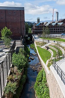
The Porter Brook featured heavily in a 2016 BBC Radio 4 documentary entitled "A River of Steel",[16] produced by sound recordist Chris Watson, ex-member of Caberet Voltaire. The programme includes discussion of the recently completed Porter Brook daylighting scheme, which also features in a 2017 article in The Guardian.[17]
Planned flood alleviation programme
In September 2014 Sheffield City Council announced plans for a flood alleviation scheme on the Porter Brook and its tributary the Mayfield Brook. It is planned to create storage dams at Mayfield, Whiteley Woods and Endcliffe Park. Downstream of Endcliffe Park, parts of the watercourse will be contained by walled defences.[18][19]
Points of interest
| Point | Coordinates (Links to map resources) |
OS Grid Ref | Notes
a |
|---|---|---|---|
| Junction with River Don | 53.3853°N 1.4622°W | SK358877 | by Blonk Street bridge |
| Start of Sheffield Station culvert | 53.3771°N 1.4632°W | SK358868 | |
| Porter Brook daylighting scheme | 53.3756°N 1.4679°W | SK354866 | |
| Start of St Mary's Gate culvert | 53.3725°N 1.4818°W | SK345863 | |
| Sharrow Snuff Mill | 53.3685°N 1.4930°W | SK338858 | |
| A625 Ecclesall Road bridge | 53.3685°N 1.4990°W | SK334858 | |
| Oakbrook Road bridge | 53.3685°N 1.5205°W | SK320858 | |
| Fulwood Lane bridge | 53.3532°N 1.5742°W | SK284841 | |
| Clough Hollow | 53.3530°N 1.5780°W | SK281840 | source |
Culverts
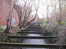
Although the 'Megatron' arches which carry the combined waters of the River Sheaf and Porter Brook under Sheffield Station and the Castlegate area, the Porter Brook is also heavily culverted as it meets the city.
As the Porter Brook descends from behind Ward's brewery, it runs under Waitrose, briefly emerging beside Baan Thai on Cemetery road. It then continues under the ring road until meeting Decathlon's car park where a section of culvert has recently been removed, opening more of the river up to the public.
Sheaf & Porter Rivers Trust
In early 2019, the Sheaf & Porter Rivers Trust was set up to encourage the regeneration and improvement of the River Sheaf & Porter Brook.[20]
Aims and Objectives of the Organisation
- Deculverting – the first priority is likely seizing the immediate opportunity at the Castle Market site where a 100 metre section of culvert is in an advanced state of decay and requires repair or removal. Other possible opportunities may arise from the master planning of the lower Sheaf Valley around the accommodation of High Speed Rail 2 at Midland Station – for instance the section of culverted river which runs between Ponds Forge leisure centre and Sheaf Street
- Daylighting – whilst removal of the culverts under the railway tracks of Midland Station is probably unrealistic the potential of sinking light‐pipes into the dark tunnels to allow fish and animal passage could be considered as part of the environmental mitigation of the scheme c) Improved public access to existing open channel sections and newly deculverted ones including access for fishing, kayaking and stewardship eg Pond Hill, Sheaf Gardens, Cutlers Walk, the Primrose etc
- Marking, celebrating the concealed course of the river where it remains hidden for now, using public art, trails etc and guided visits using trained guides
- Interpretation of the river’s history, wildlife and environmental functions and engagement with its neighbouring communities
- Promotion of good practice by riparian owners
- More sustainable urban drainage in the Sheaf corridor following the example of Grey to Green
Porter Brook Path
A new riverside path is planned between where the Porter Brook first goes underground at Hunters Bar Roundabout, through Sharrowvale, past the general cemetery and towards the cultural industries quarter. From here, it will meet the Matilda Street Pocket Park and continue to Sheffield Station.
This is a long term plan and current relies on several riverside redevelopment sites which have promised to create new sections of riverside walk.
Matilda Street Pocket Park
The Matilda Street Pocket Park was one of Sheffield's first examples of natural flood management in an urban environment. The newly created pocket park provides both a public park and extra space for the previously narrow river to hold back and slow flood water.[21]
The new park was a joint effort between Don Catchment Rivers Trust, South Yorkshire Forest, the Environment Agency, Wild Trout Trust and Sheffield City Council.
The project was announced as the Winner in the ‘Contribution to the Built Environment’ category at the 2016 Living Waterways Awards ceremony, held at Birmingham Town Hall last night (14 September 2016)[22]
Funding came from the Councils City Centre Breathing Spaces programme and the Environment Agency Local Levy.
Bibliography
- Ball, Christine; Crossley, David; Flavell, Neville (2006). Water Power on the Sheffield Rivers: Second Edition. South Yorkshire Industrial History Society. ISBN 978-0-9556644-0-3.CS1 maint: ref=harv (link)
References
- "Walking with Ramblers: Walk 2 Mayfield and Porter Valleys" (PDF). Sheffield City Council. Retrieved 18 August 2019.
- Goodwin, David (20 November 2009). "Geograph:: Rotary Orientation table (C) DAVID M GOODWIN". www.geograph.org.uk. Retrieved 18 August 2019.
- "City Policies and-Sites" (PDF). www.sheffield.gov.uk. Sheffield City Council. 3 April 2013. Retrieved 17 March 2017.
- 53.3786°N 1.4630°W
- Ball, Crossley & Flavell 2006, p. 114
- Ball, Crossley & Flavell 2006, pp. 115–117
- "Regeneration of Porter Brook". Sheffield City Council. Archived from the original on 2 December 2008. Retrieved 10 January 2018.
- Ball, Crossley & Flavell 2006, pp. 117–118
- Ball, Crossley & Flavell 2006, pp. 119–121
- Signboards erected in Eastwood Road micro park
- OS Map 1810
- "Glossary (see Biological quality element; Chemical status; and Ecological status)". Catchment Data Explorer. Environment Agency. Retrieved 15 May 2017.
- "Porter from Source to River Sheaf". Catchment Data Explorer. Environment Agency. Retrieved 21 August 2019.
- "Wickerman (song)". Retrieved 5 December 2011.
- "Five Rivers Morris repertoire | Five Rivers Morris". www.fiveriversmorris.org.uk. Retrieved 13 February 2017.
- "A River of Steel (Radio Programme)". Retrieved 8 September 2017.
- "A river runs through it (Article)". Retrieved 8 September 2017.
- "Sheaf Catchment Options Map | Protecting Sheffield from Flooding". www.floodprotectionsheffield.com. Retrieved 9 November 2017.
- "£55m flood defence plans revealed". BBC News. 11 September 2014. Retrieved 9 November 2017.
- https://www.sheafportertrust.org/about-us Sheaf & Porter Rivers Trust
- "matilida street pocket park - Google Search". www.google.com. Retrieved 7 July 2020.
- Council, Sheffield City. "Porter Brook Pocket Park wins prestigious Living Waterways Award | Sheffield Newsroom | Sheffield City Council". Retrieved 7 July 2020.
External links
- Sheffield City Library – historical photographs, prints, and old postcards
- Friends of the Porter Valley – preserving the past and existing dams
![]()