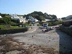
Port Gaverne
Port Gaverne (Cornish: Porthkaveran[1]) is a hamlet on the north coast of Cornwall, England, UK, about half a mile east of Port Isaac.[2]
Port Gaverne
| |
|---|---|
 | |
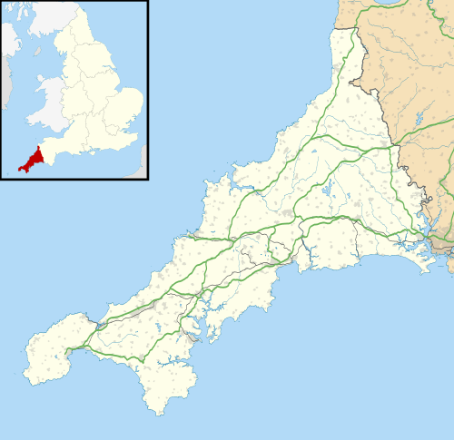 Port Gaverne Location within Cornwall | |
| OS grid reference | SX003808 |
| Civil parish | |
| Unitary authority | |
| Ceremonial county | |
| Region | |
| Country | England |
| Sovereign state | United Kingdom |
| Post town | PORT ISAAC |
| Postcode district | PL29 |
| Dialling code | 01208 |
| Police | Devon and Cornwall |
| Fire | Cornwall |
| Ambulance | South Western |
| UK Parliament | |
Although it is an independent hamlet, some consider it as part of the larger village of Port Isaac which is located around the headland.
Historically, Port Gaverne existed as an export port for slate from the local mine, and for the local fishing catch, particularly pilchards. Nowadays the settlement relies upon tourism.
Etymology
The name ‘Gaverne’ is thought to have come from 'Karn Hun', which means ‘rocky haven‘. It is still spelled 'Gavern' by some locals - pronounced 'gay-verne'.[3]
History
Port Gaverne was a small port similar to many on the north coast of Cornwall, but there are few references to the settlement in history before the nineteenth century.[4] Writing in 1584, John Norden said “Port-kerne, a litle cove for fisher-boates; and ther was somtymes a crane to lifte up and downe suche comodities as were ther taken in to be transported, or browght in and unloden: and ther have bene divers buyldinges, now all decayde since the growing of Portissick {Port Isaac}”.
In 1762 there is a reference to a lease of some land for loading sand; sand from the sea was rich in lime and used as fertiliser on Cornish soils. Historian Sir John Maclean mentions in 1872 that women and children earned a good income by harvesting sand. This activity continued into the 20th century.[4]
In 1802 Warwick Guy leased land to build a fish cellar, one of four eventually constructed by the Guy family, who continued to live and work in the area for the next hundred years. The fish cellars are still extant.[4] The fishing season was only two months long, but catches were large. In 1811 it was recorded that two of the fish cellars handled over 225 tons of fish during one week. There was also some shipbuilding here.[5]
The port’s principal trade was the export of slate from the large Delabole Quarry to the northeast, those sailing ketches being too wide for the harbour at Port Isaac.[6] Coal was imported and other local produce, particularly pilchards,[3] was exported. In 1859, Murrays Handbook of Devon and Cornwall recorded that "the quarries present one of the most astonishing and animated scenes imaginable". About 1,000 men were employed, raising about 120 tonnes of slate per day. This was cut and hauled six miles to Port Gaverne where it would be loaded onto ships in the harbour. Thirty wagons, pulled by over a hundred horses, would load a sixty ton ship. As late as 1890, women still helped with stowing the slates.[7]
Some time between 1873 and 1880, the road to Port Isaac was excavated by convicts from Dartmoor Prison, to enable slate to be carried there by road rather than ferried around the headland.[8]
However, when the North Cornwall Railway (absorbed by the London & South Western Railway) line to Wadebridge opened in the 1890s, transport of Delabole slate switched to rail and Port Gaverne lost most of its trade. The pilchard trade continued, until the fish disappeared forcing the fishing boats to move away.[9]
Quickly, the local economy adapted to cater for visitors. In 1897, sail lofts were converted to accommodation for school groups. By 1906 there were two cafes in the hamlet, and six bathing huts on the beach. The Union Inn, now the Port Gaverne Hotel, began to accommodate tourists, and ‘Headlands’ became a hotel.[4]
During the Second World War, the village hosted many evacuees, and the fish cellars were converted into homes for the children, along with the now empty clifftop Headlands Hotel. Some of these cellars now provide holiday accommodation.[9] A series of tank traps were installed in the cove in case of German invasion.[10]
Geography
The Draft Neighbourhood Plan describes the local coastline as "particularly rugged, unique and spectacular", "recognised as a heritage coast, whilst inland the area remains extensively unspoilt with prevailing rural characteristics".[11] The hamlet lies within the Pentire Point to Widemouth Section of the Cornwall Area of Outstanding Natural Beauty. According to the AONB Management Plan, the local area has "a noticeable lack of tree cover due to the exposure to coastal winds". Land use is "mainly agricultural grazing in small to medium sized fields of medieval origin although modern farming practice has resulted in some larger fields being created". There is also coastal heathland with "rough and scrubby land leading inwards from the coast".[12]
The buildings of the hamlet have mostly remained unchanged for two hundred years.[4] The steep hillsides enclosing the hamlet have forced developers to look at the flat, if exposed, land on the headland between Ports Gaverne and Isaac for new build.[8] The AONB Management Plan describes slate as "the characteristic local building and hedging material, varying from the mid hues of Delabole slate to the darker shades sourced at Trebarwith".[12] The Draft Neighbourhood Plan identifies Port Gaverne as a "Character Area" that contains a number of listed buildings including the former fish cellars, with planning restrictions to ensure that any development "respects and maintains the character of the area".[11]
Governance
Port Gaverne is part of the Cornwall Council local authority area, covering the county of Cornwall. The council is a unitary authority; the local ward is St Minver & St Endellion, which was won at the last 2017 local election by the Conservative candidate Carole Mould, having previously been represented by an Independent, Andy Penny. The hamlet is part of the North Cornwall parliamentary constituency, represented since 2015 by Conservative MP Scott Mann.
The local parish council is St Endellion. The parish takes its name from Saint Endelienta, who is said to have evangelised the district in the fifth century and to have been one of the children of King Brychan. The parish is currently developing a Neighbourhood Development Plan.[13]
Demography
According to the 2011 census, the population of the parish was 1,029 in 480 households. Of these residents, 120 were aged under 16, and 320 aged 65 or over. 485 were recorded as economically active.[11] In 2015 a local magazine reported there were just twenty remaining residents in Port Gaverne itself.[9]
The population of the parish is declining, as younger groups (particularly families) move away in search of job opportunities and more affordable housing.[14]
Economy and Services
The historic principal occupations within the parish of fishing and agriculture have been displaced by tourism, which has boomed, particularly since Port Isaac became the filming location for the current ITV television series Doc Martin in 2004 and for the 2019 feature film Fisherman's Friends, both of which included shooting in Port Gaverne. A 2013 Plymouth University study found that visitors had "clear destination images of Port Isaac prior to their visit", with the television series acting as "a display window for the village and surrounding area". The research indicated that it "acted as a key influence on intention to visit", particularly for more educated middle aged tourists.[15] Port Gaverne is also known as a popular site for diving and for launching boats for fishing trips.[16]
The hamlet relies upon nearby Port Isaac for almost all services, as there are none in Port Gaverne other than Port Gaverne Hotel. The county council profiles the settlement as being associated with Port Isaac.[17] According to the Draft Neighbourhood Plan, as of 2019 Port Isaac had nine restaurants, one takeaway, eighteen shops and three public houses, with Port Gaverne having just the public house/cafe/restaurant at the hotel.[11]
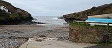
The beach is now maintained by the National Trust[3], having been bequeathed to it by a local family to protect the character of the cove, and by Port Gaverne Beach Association.
The village mostly consists of holiday accommodation.[9] In 2007/8 the housing affordability ratio (defined as median house prices as a ratio of median incomes) of the parish was recorded at 48.6, compared to the English average of 15.4.[11]
Transport
The hamlet is accessible by narrow single track lanes, from Port Isaac and the B3267 from the west, and from the junction with the B3314 three miles to the east. Parking is exceptionally difficult in the hamlet itself, but there is a larger car park on top of the headland toward Port Isaac. The area is popular with walkers and for dog walking, with many local footpaths including the Cornish Coastal Path. The 96 bus service runs along the B3314 and into Port Isaac four times daily, connecting to Wadebridge and Delabole.[11]
References
| Wikimedia Commons has media related to Port Gaverne. |
- "Wayback Machine". Web.archive.org. 10 May 2013. Archived from the original on 10 May 2013. Retrieved 19 August 2017.CS1 maint: BOT: original-url status unknown (link)
- Ordnance Survey Landranger 200; Newquay, Bodmin & surrounding area, 1:50 000. 1988
- "Port Gaverne beach". www.visitcornwall.com. Visit Cornwall. Retrieved 25 July 2020.
- "Changing fortunes at Port Gaverne". www.gullrock-Port-gaverne.co.uk. Retrieved 25 July 2020.
- "Ports and Harbours of the UK: Port Gaverne". www.ports.org.uk. Retrieved 25 July 2020.
- "Port Gaverne". www.cornwalls.com. Retrieved 25 July 2020.
- "History". www.delaboleslate.co.uk. 2013. Retrieved 25 July 2020.
- "Port Isaac Conservation Area Appraisal" (PDF). Cornwall County Council. p. 9. Retrieved 25 July 2020.
- "Secret Cornwall: Port Gaverne". Cornwall Life Magazine. March 2015. Retrieved 25 July 2020.
- "Protecting Port Gaverne". www.bbc.co.uk. BBC. 11 July 2005. Retrieved 25 July 2020.
- "St Endellion Neighbourhood Development Plan 2019-2030" (PDF). www.stendellionpc.com. St Endellion Parish Council. Retrieved 26 July 2020.
- "Cornwall AONB Local Sections" (PDF). Landscapes for Life. Retrieved 26 July 2020.
- "Neighbourhood Plan". www.stendellionpc.com. St Endellion Parish Council. Retrieved 26 July 2020.
- "Rural community profile for St. Endellion" (PDF). Action with Communities in Rural England. Retrieved 26 July 2020.
- Busby, Graham; Haines, Callum. "Doc Martin and film tourism: The creation of destination image" (PDF). www.stendellionpc.com. Plymouth University. Retrieved 26 July 2020.
- "PORT GAVERNE SHORE DIVE". www.atlanticscuba.co.uk. Atlantic Scuba. Retrieved 26 July 2020.
- "Settlement Profile:Port Isaac/Port Gaverne" (PDF). www.cornwall.gov.uk. Cornwall County Council. 2009. Retrieved 26 July 2020.
Cornwall Portal | |
| Unitary authorities | |
| Major settlements |
|
| Rivers | |
| Topics | |