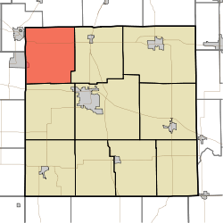
Polk Township, Marshall County, Indiana
Polk Township is one of ten townships in Marshall County, Indiana, United States. As of the 2010 census, its population was 2,824 and it contained 1,183 housing units.[1]
Polk Township | |
|---|---|
 Location in Marshall County | |
| Coordinates: 41°25′44″N 86°24′39″W | |
| Country | |
| State | |
| County | Marshall |
| Government | |
| • Type | Indiana township |
| Area | |
| • Total | 42.24 sq mi (109.4 km2) |
| • Land | 42.09 sq mi (109.0 km2) |
| • Water | 0.16 sq mi (0.4 km2) 0.38% |
| Elevation | 738 ft (225 m) |
| Population (2010) | |
| • Total | 2,824 |
| • Density | 67.1/sq mi (25.9/km2) |
| ZIP codes | 46563, 46574 |
| GNIS feature ID | 0453755 |
History
Polk Township was organized on March 4, 1845. The date of the township's organization coincided with the inauguration of James K. Polk, hence the name.[2]
The Polk Township District No. 2 School was listed on the National Register of Historic Places in 2013.[3]
Geography
According to the 2010 census, the township has a total area of 42.24 square miles (109.4 km2), of which 42.09 square miles (109.0 km2) (or 99.64%) is land and 0.16 square miles (0.41 km2) (or 0.38%) is water.[1]
Unincorporated towns
- Koontz Lake (east edge)
- Teegarden at 41.465046°N 86.377509°W
- Tyner at 41.409767°N 86.402509°W
Cemeteries
The township contains Barber Cemetery Blissville Cemetery and Tyner Cemetery.
Major highways
Airports and landing strips
- Stuntz and Hochstetler Pines Airport
School districts
- John Glenn School Corporation
Political districts
- Indiana's 2nd congressional district
- State House District 17
- State Senate District 5
gollark: You'd probably have to have people set up realistic conversation in fake channels in advance.
gollark: Oh, so you're saying that inductively safety is *always* 0?
gollark: No, none *will ultimately be* safe, not none *can be* safe.
gollark: It says "for all x, as time tends to infinity, safety of x tends to 0".
gollark: That is NOT what that says.
References
- "Polk Township, Marshall County, Indiana". Geographic Names Information System. United States Geological Survey. Retrieved 2009-09-29.
- United States Census Bureau 2008 TIGER/Line Shapefiles
- IndianaMap
- "Population, Housing Units, Area, and Density: 2010 - County -- County Subdivision and Place -- 2010 Census Summary File 1". United States Census. Archived from the original on 2020-02-12. Retrieved 2013-05-10.
- McDonald, Daniel (1908). A Twentieth Century History of Marshall County, Indiana, Volume 1. Lewis Publishing Company. p. 87.
- "National Register of Historic Places Listings". Weekly List of Actions Taken on Properties: 1/07/13 through 1/11/13. National Park Service. 2013-01-18.
External links
This article is issued from Wikipedia. The text is licensed under Creative Commons - Attribution - Sharealike. Additional terms may apply for the media files.