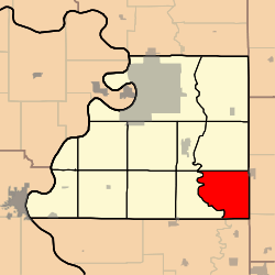
Platte Township, Buchanan County, Missouri
Platte Township is one of twelve townships in Buchanan County, Missouri, USA. As of the 2000 census, its population was 416.
Platte Township | |
|---|---|
 | |
| Coordinates: 39°35′44″N 094°38′58″W | |
| Country | United States |
| State | Missouri |
| County | Buchanan |
| Area | |
| • Total | 30.77 sq mi (79.69 km2) |
| • Land | 30.76 sq mi (79.66 km2) |
| • Water | 0.01 sq mi (0.03 km2) 0.04% |
| Elevation | 899 ft (274 m) |
| Population (2000) | |
| • Total | 416 |
| • Density | 13.5/sq mi (5.2/km2) |
| FIPS code | 29-58124[2] |
| GNIS feature ID | 0766343 |
Platte Township was established in 1839, taking its name from the Platte River.[3]
Geography
Platte Township covers an area of 30.77 square miles (79.7 km2) and contains no incorporated settlements. It contains six cemeteries: Allen, Frazier, Hebron, Number 6, Tobin and Witts.
The streams of Belcher Branch, Castile Creek, Crabapple Branch, DeMoss Branch, Frazier Branch, Jenkins Branch, Malden Creek and Wolfpen Creek run through this township.
gollark: - C-like includes (does PHP7 fix this?)
gollark: (well, often a security issue)
gollark: - deploy-by-copying-files - produces nasty URLs and is a security issue
gollark: I think it mostly just depends on language sanity and library support.
gollark: Yes, that is true.
References
- "US Board on Geographic Names". United States Geological Survey. 2007-10-25. Retrieved 2008-01-31.
- "U.S. Census website". United States Census Bureau. Retrieved 2008-01-31.
- "Buchanan County Place Names, 1928–1945 (archived)". The State Historical Society of Missouri. Archived from the original on 24 June 2016. Retrieved 4 September 2016.CS1 maint: BOT: original-url status unknown (link)
External links
Municipalities and communities of Buchanan County, Missouri, United States | ||
|---|---|---|
| Cities | 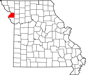 Map of Missouri highlighting Buchanan County | |
| Villages | ||
| Townships | ||
| Unincorporated communities | ||
| Footnotes | ‡This populated place also has portions in an adjacent county or counties | |
This article is issued from Wikipedia. The text is licensed under Creative Commons - Attribution - Sharealike. Additional terms may apply for the media files.