Pitt Island (Canada)
Pitt Island is an island located within the traditional territory of the Gitxaala Nation on the north coast of British Columbia, Canada[1].
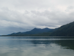 Northern End of Pitt Island as seen from Grenville Channel | |
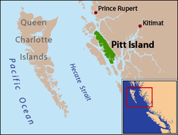 Pitt Island is located between Banks Island and the mainland. | |
| Geography | |
|---|---|
| Coordinates | 53°30′00″N 129°47′00″W |
| Area | 1,368 km2 (528 sq mi) |
| Length | 90 km (56 mi) |
| Width | 8 km (5 mi) |
| Highest elevation | 962 m (3,156 ft) |
| Administration | |
Canada | |
| Province | British Columbia |
Pitt island is located between Banks Island, across Grenville Channel (part of the Inside Passage) from the mainland, and is separated from Banks Island by Principe Channel[2]. The island has an area of 1,368 square kilometres (528 sq mi), is 90 kilometres (56 mi) long, and ranges from 8 to 23 kilometres (5.0 to 14.3 mi) wide. Its highest point is at 962 metres (3,156 ft).
Pitt Island is the only island in British Columbia known to host a resident population of Moose[3]
Features
Protected Areas
- Union Passage Marine Provincial Park[19]
- Maxtaktsm'Aa/Union Passage Conservancy[20]
- Monckton Nii Luutiksm Conservancy[21]
- Pa-aat Conservancy[22]
gollark: It had an issue where it emitted the Quake fast inverse square root thing verbatim.
gollark: I finetuned GPT-2 117M on my Discord messages one time. It only needed a CSV file trivially generated from the GDPR data dump.
gollark: GPT-2/3 are just trained off unstructured unlabelled text. So they'd basically only need a HTML parser.
gollark: It would actually have been quite easy for them.
gollark: Unfortunately, that project did not work and has been consigned to history.
References
| Wikimedia Commons has media related to Pitt Island (British Columbia). |
- Iain McKechnie. Archaeological Research in Southern Gitxaała Territory, Pitt and Banks Islands, August 2009 (PDF) (Report). University of British Columbia. Retrieved 2020-06-22.
- "Pitt Island". BC Geographical Names.
- Price Michael H, Darimont Chris T, Winchester Neville N, Paquet Paul C (2005). "Facts from faeces: prey remains in Wolf, Canis lupus, faeces revise occurrence records for mammals of British Columbia's coastal archipelago". Canadian Field-Naturalist. 119 (2): 192–196. Retrieved 2020-06-22.
- "Anchor Mountain". BC Geographical Names.
- "Captain Cove". BC Geographical Names.
- "Holmes Lake". BC Geographical Names.
- "Hevenor Inlet". BC Geographical Names.
- "Newcombe Harbour". BC Geographical Names.
- "Pa-aat River". BC Geographical Names.
- "Port Stevens". BC Geographical Names.
- "Monckton Inlet". BC Geographical Names.
- "Mount Hulke". BC Geographical Names.
- "Mount Patterson". BC Geographical Names.
- "Mount Frank". BC Geographical Names.
- "Mount Saunders". BC Geographical Names.
- "Mount Shields". BC Geographical Names.
- "Wyndham Lake". BC Geographical Names.
- "Red Bluff Lake". BC Geographical Names.
- "Union Passage Marine Park". BC Geographical Names.
- "Maxtaktsm'Aa/Union Passage Conservancy". BC Geographical Names.
- "Monckton Nii Luutiksm Conservancy". BC Geographical Names.
- "Pa-aat Conservancy". BC Geographical Names.
This article is issued from Wikipedia. The text is licensed under Creative Commons - Attribution - Sharealike. Additional terms may apply for the media files.