Captain Cove
Captain Cove is a cove located within the traditional territory of the Gitxaala Nation, on Pitt Island, British Columbia, Canada. Currently named after Captain Holmes Newcombe of the Fisheries Department[2].
| Captain Cove | |
|---|---|
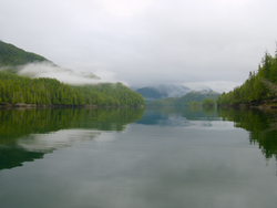 Looking up Captain Cove, Pitt Island, from Captain Point | |
 Captain Cove | |
| Location | British Columbia, Canada |
| Coordinates | 53°48′44″N 130°11′49″W |
| Type | Fjord |
| Native name | Kla’tin[1] |
| Part of | Pitt Island |
| Max. length | 1 nautical mile (1.9 km; 1.2 mi) |
| Max. width | 0.375 nautical miles (0.695 km; 0.432 mi) |
| Max. depth | 20 fathoms (120 ft; 37 m) |
The cove is 1 nautical mile (1.9 km; 1.2 mi) long and between 0.125–0.375 nautical miles (0.232–0.695 km; 0.144–0.432 mi) wide, and contains several islets, approximately 0.5 nautical miles (0.93 km; 0.58 mi) east of Captain Point[3]. The cove is underlain by the large 100 by 25 kilometres (62 by 16 mi) Captain Cove Pluton dating to the Albian (109±6Ma)[4].
The cove preserves a record of intense prehistoric use, with a few large shell middens and several small shell middens associated with creeks flowing into the cove.
| Wikimedia Commons has media related to Captain Cove. |
References
- MARSDEN S. REPORT SUBMITTED TO (2011). THE GITKXAALA, THEIR HISTORY, AND THEIR TERRITORIES (PORCHER ISLAND, BANKS ISLAND, PITT ISLAND AND ADJACENT ISLANDS) (pdf) (Report). JANES FREEDMAN KYLE LAW CORPORATION. p. 55.CS1 maint: uses authors parameter (link)
- "Captain Cove". BC Geographical Names.
- "Chart 3746, Petrel Channel". Sailing Directions, British Columbia Coast, (Northern Portion). II (Ninth Edition): 259. 1983.
- Symons DT (1977). "Paleomagnetism of Mesozoic plutons in the westernmost Coast Complex of British Columbia". Canadian Journal of Earth Sciences. 14 (9): 2127–39. Retrieved 2020-07-11.
This article is issued from Wikipedia. The text is licensed under Creative Commons - Attribution - Sharealike. Additional terms may apply for the media files.