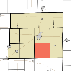
Pike Township, Jay County, Indiana
Pike Township is one of twelve townships in Jay County, Indiana, United States. As of the 2010 census, its population was 899 and it contained 355 housing units.[1]
Pike Township | |
|---|---|
 The James Haines Farm, a historic site in the township | |
 Location in Jay County | |
| Coordinates: 40°20′54″N 84°57′41″W | |
| Country | United States |
| State | Indiana |
| County | Jay |
| Government | |
| • Type | Indiana township |
| Area | |
| • Total | 37.29 sq mi (96.6 km2) |
| • Land | 37.27 sq mi (96.5 km2) |
| • Water | 0.01 sq mi (0.03 km2) 0.03% |
| Elevation | 991 ft (302 m) |
| Population (2010) | |
| • Total | 899 |
| • Density | 24.1/sq mi (9.3/km2) |
| GNIS feature ID | 0453734 |
History
Pike Township was organized in 1837.[2]
The James Haines Farm was listed on the National Register of Historic Places in 2000.[3]
Geography
According to the 2010 census, the township has a total area of 37.29 square miles (96.6 km2), of which 37.27 square miles (96.5 km2) (or 99.95%) is land and 0.01 square miles (0.026 km2) (or 0.03%) is water.[1] The streams of Buckeye Creek, Buckeye Creek, Old Run, Rest Run and Sale Run run through this township. The Goshen Creek also runs through this township.
Unincorporated towns
Adjacent townships
- Wayne Township (north)
- Noble Township (northeast)
- Madison Township (east)
- Jackson Township, Randolph County (southeast)
- Ward Township, Randolph County (south)
- Franklin Township, Randolph County (southwest)
- Jefferson Township (west)
- Greene Township (northwest)
Cemeteries
The township contains seven cemeteries, 3 of which still operate- in operation- Antioch Cemetery, Boundary Cemetery and Zoar Cemetery. Non operated cemeteries are Clark Family Burial Ground, Hawkins Cemetery, Kunce Cemetery, and an unnamed cemetery on land owned by Margaret R. Warren c/o Robin Khayyata, according to the public record.
Major highways
References
- "Population, Housing Units, Area, and Density: 2010 - County -- County Subdivision and Place -- 2010 Census Summary File 1". United States Census. Archived from the original on 2020-02-12. Retrieved 2013-05-10.
- Jay, Milton T. (1922). History of Jay County, Indiana: Including Its World War Record and Incorporating the Montgomery History, Volume 1. Historical Publishing Company. p. 106.
- "National Register Information System". National Register of Historic Places. National Park Service. July 9, 2010.