Phu Kradueng District
Phu Kradueng (Thai: ภูกระดึง; IPA: [pʰūː krādɯ̄ŋ]) is a district (amphoe) of Loei Province, northeastern Thailand.
Phu Kradueng ภูกระดึง | |
|---|---|
 | |
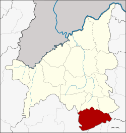 District location in Loei Province | |
| Coordinates: 16°53′3″N 101°53′4″E | |
| Country | Thailand |
| Province | Loei |
| Seat | Phu Kradueng |
| Area | |
| • Total | 709.0 km2 (273.7 sq mi) |
| Population (2005) | |
| • Total | 33,438 |
| • Density | 47.2/km2 (122/sq mi) |
| Time zone | UTC+7 (ICT) |
| Postal code | 42180 |
| Geocode | 4210 |
Geography
Neighboring districts are (from the north clockwise): Phu Luang, Nong Hin, and Pha Kao of Loei Province; Si Bun Rueang of Nong Bua Lamphu Province; Si Chomphu, Chum Phae, and Phu Pha Man of Khon Kaen Province; and Nam Nao of Phetchabun Province.
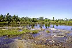
Phu Kradueng mountain is in the district.
History
The minor district (king amphoe) was created on 1 January 1962, when the three tambons, Si Than, Puan Phu, and Pha Khao, were split off from Wang Saphung District.[1] It was upgraded to a full district on 16 July 1963.[2]
Administration
The district is divided into four sub-districts (tambons), which are further subdivided into 54 villages (mubans). Phu Kradueng is a township (thesaban tambon) which covers parts of tambons Si Than, Pha Nok Khao, and Phu Kradueng. There are a further four tambon administrative organizations (TAO).
| No. | Name | Thai name | Villages | Pop. | |
|---|---|---|---|---|---|
| 1. | Si Than | ศรีฐาน | 16 | 10,963 | |
| 5. | Pha Nok Khao | ผานกเค้า | 14 | 8,140 | |
| 7. | Phu Kradueng | ภูกระดึง | 13 | 7,698 | |
| 10. | Huai Som | ห้วยส้ม | 11 | 6,637 |
Missing numbers are tambons which now form the Districts Pha Khao and Nong Hin.
References
- ประกาศกระทรวงมหาดไทย เรื่อง การแบ่งท้องที่ตั้งเป็นกิ่งอำเภอ (PDF). Royal Gazette (in Thai). 79 (4 ง): 32–33. 9 January 1962.
- พระราชกฤษฎีกาตั้งอำเภอบ่อพลอย อำเภอไทรโยค อำเภอหนองปรือ อำเภอหนองสองห้อง อำเภอประทาย อำเภอห้วยแถลง อำเภอละหานทราย อำเภอกุยบุรี อำเภอตาพระยา อำเภอหนองไผ่ อำเภอนาเชือก อำเภอวัดเพลง อำเภอพนัสนิคม อำเภอภูกระดึง อำเภอปรางค์กู่ อำเภอท่าช้าง อำเภอบ้านด่านลานหอย อำเภอบ้านดุง อำเภอสว่างอารมณ์ และอำเภอกุดชุม พ.ศ. ๒๕๐๖ (PDF). Royal Gazette (in Thai). 80 (72 ก): 362–366. 16 July 1963.
| Wikimedia Commons has media related to Phu Kradueng District. |