Pensnett Canal
The Pensnett Canal, also called Lord Ward's Canal was a private 1.25 miles (2 km) long canal near Brierley Hill, West Midlands, England.[1] The engineer was Mathew Frost.[2] It has now almost entirely been lost by overbuilding.
| Pensnett Canal | |
|---|---|
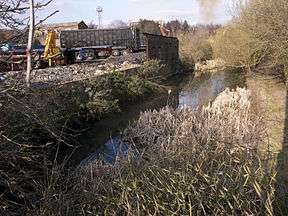 One of the few parts of the canal in water | |
| Specifications | |
| Length | 1.25 miles (2.01 km) |
| Maximum height above sea level | 473 ft (144 m) (Wolverhampton Level) |
| Status | Mostly infilled |
| History | |
| Construction began | 1839 |
| Date completed | 1840 |
| Date closed | 1950 |
| Geography | |
| Start point | Parkhead Junction |
| End point | Round Oak Steelworks |
| Connects to | Dudley Canal |
It ran from Parkhead Basin at the southern portal of the Dudley Canal tunnel to the Wallows Wharf[3] to serve the Earl of Dudley's coalfields (Old Park and Wallows Collieries) and the northern part of his (now demolished) Round Oak Steelworks, where a short railway ran to the Staffordshire and Worcestershire Canal.[3][4] The Dudley No. 1 Canal ran close to the southern part of that works.
It was also known as Lord Ward's Canal although there is an identically named branch from the northern portal of the Dudley Tunnel. Baron Ward was another title of the Earl of Dudley.
The canal is completely unnavigable, having been partly infilled and in many places built upon by industrial premises. The remaining canal was reported by the local council to be contaminated.[5] A short length, now called Pensnett Basin, runs between Parkhead Junction and an arch of the Parkhead Viaduct, where the arch has been closed off. There is no further access to the former canal although a public footpath follows a short distance over the course between factories. The course of the canal can also be observed from a number of road bridges.
Points of interest
| Point | Coordinates (Links to map resources) |
OS Grid Ref | Notes
a |
|---|---|---|---|
| Start. Junction with Dudley Canal at Parkhead Basin | 52.49956°N 2.10004°W | SO93208911 | |
| Limit of navigation in Pensnett Basin | 52.49868°N 2.09984°W | SO93228902 | |
| Parkhead Viaduct | 52.49851°N 2.09978°W | SO93228900 | |
| East end of public footpath between factories | 52.49292°N 2.10338°W | SO92988838 | |
| West end of public footpath between factories. Pedmore Road bridge. | 52.4922°N 2.1058°W | SO92818830 | |
| Canal used as industrial cooling pool | 52.49223°N 2.10550°W | SO92838830 | |
| Rail bridge | 52.49195°N 2.11069°W | SO92488827 | |
| Canal Street bridge | 52.49099°N 2.11276°W | SO92348816 | |
| Site of Round Oak Steelworks | 52.4886°N 2.1166°W | SO920879 | |
| Site of Harthill Iron Works | 52.4915°N 2.1125°W | SO92368822 | |
| A461 Dudley Road bridge | 52.49020°N 2.11800°W | SO91988807 | |
| Terminus (approx). The Wallows, Hope Works, start of Mineral Railway to Stourbridge Canal. | 52.4908°N 2.1199°W | SO91858814 | |
| Terminus (approx) of Mineral Railway by Stourbridge Canal | 52.4936°N 2.1289°W | SO9125884 |
References
- "Pensnett Canal". UK Canals Network. Retrieved 22 March 2012.
- "Pensnett Canal". Birmingham Canal Navigations Society. Retrieved 3 May 2012.
- Shill, Ray (1996). The Industrial Canal - Volume 1 The Coal Trade. Three Spires Print and Design. ISBN 0-9517755-5-3.
- "Pensnett Canal". Waterways of the UK. Archived from the original on 26 August 2014. Retrieved 22 March 2012.
- "Brierley Hill Area Action Plan Publication Baseline Report". Dudley Metropolitan Borough Council. Archived from the original on 5 August 2012. Retrieved 23 March 2012.
| Wikimedia Commons has media related to Pensnett Canal. |