Penokee, Kansas
Penokee is an unincorporated community in Graham County, Kansas, United States, in the Solomon Valley.[2]
Penokee, Kansas | |
|---|---|
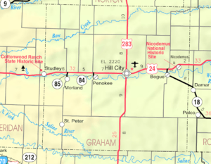 KDOT map of Graham County (legend) | |
 Penokee  Penokee | |
| Coordinates: 39°21′4″N 99°58′20″W | |
| Country | United States |
| State | Kansas |
| County | Graham |
| Founded | 1880s |
| Platted | 1888 |
| Elevation | 2,224 ft (678 m) |
| Time zone | UTC-6 (CST) |
| • Summer (DST) | UTC-5 (CDT) |
| Area code | 785 |
| FIPS code | 20-55375 |
| GNIS ID | 472354[1] |
History
The community was originally named Reford and platted in 1888 when the railroad was extended to that point.[3] Because the town became mistaken for Rexford, Kansas, the residents renamed their town after the Penokee Mountains near Lake Superior.
Education
The community is served by Graham County USD 281 public school district.
gollark: <:dcegg:325264593536679937> = mc²
gollark: Well, if you were observing an egg from something moving at relativistic speeds, then it would - to you - age faster, I guess, yes.
gollark: If I remember correctly, travelling faster means the external world moves faster to you.
gollark: THAT'S ENTIRELY REASONABLE!
gollark: WHAT'S THE PROBLEM?
References
- "US Board on Geographic Names". United States Geological Survey. 1978-10-13. Retrieved 2017-12-30.
- "Penokee, Kansas". Geographic Names Information System. United States Geological Survey.
- "Origin of Town Names" (PDF). Solomon Valley Highway 24 Heritage Alliance. p. 5. Retrieved 9 April 2018.
Further reading
External links
Municipalities and communities of Graham County, Kansas, United States | ||
|---|---|---|
| Cities | 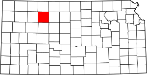 Map of Kansas highlighting Graham County | |
| Unincorporated communities | ||
| Ghost towns | ||
| Townships | ||
This article is issued from Wikipedia. The text is licensed under Creative Commons - Attribution - Sharealike. Additional terms may apply for the media files.