Pawcatuck, Connecticut
Pawcatuck is a village[1] and census-designated place (CDP) in the town of Stonington which is located in New London County, Connecticut. The population was 5,624 at the 2010 census.[2] It is located across the Pawcatuck River from Downtown Westerly, Rhode Island. The Mechanic Street Historic District of Pawcatuck is listed on the National Register of Historic Places and includes sites of shipbuilding, mills, and worker housing in a 147-acre (0.59 km2) area.[3]
Pawcatuck | |
|---|---|
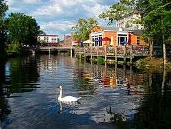
 Pawcatuck River next to the village | |
| Coordinates: 41°22′38″N 71°50′01″W | |
| Country | United States |
| State | Connecticut |
| Town | Stonington |
| Area | |
| • Total | 3.42 sq mi (8.9 km2) |
| • Land | 3.41 sq mi (8.8 km2) |
| • Water | 0.012 sq mi (0.03 km2) |
| Population (2010) | |
| • Total | 5,624 |
| • Density | 1,644.4/sq mi (634.9/km2) |
Demographics
The village of Pawcatuck has a total area of 3.42 square miles (8.87 km2)[4] bordered to the east by the Pawcatuck River. As of the census[5] of 2000, there were 5,474 people, 2,427 households, and 1,439 families residing in the village. The population density was 1,479.9 people per square mile (571.2/km2). There were 2,598 housing units at an average density of 702.4 per square mile (271.1/km2). The racial makeup was 93.53% White, 0.75% African American, 0.69% Native American, 2.12% Asian, 0.05% Pacific Islander, 0.69% from other races, and 2.16% from two or more races. Hispanic or Latino of any race were 1.44% of the population. The median income for a household in Pawcatuck was $39,799, and the median income for a family was $53,087, and 9.3% of the population was below the poverty line.
See also

References
- Principal Communities in Connecticut, Dept. of Economic and Community Development
- "Profile of General Population and Housing Characteristics: 2010 Demographic Profile Data (DP-1): Pawcatuck CDP, Connecticut". United States Census Bureau. Retrieved October 29, 2012.
- "National Register Information System". National Register of Historic Places. National Park Service. March 13, 2009.
- "Geographic Identifiers: 2010 Demographic Profile Data (G001): Pawcatuck CDP, Connecticut". United States Census Bureau. Retrieved October 29, 2012.
- "U.S. Census website". United States Census Bureau. Retrieved 2008-01-31.
