Parish of Warruera
Parish of Warruera, New South Wales Located at 29.624722°S 144.178611°E, six Kilometers north of Wanaaring, New South Wales is a cadastral parish of Ularara County New South Wales.[1][2]
History
The parish is on the Paroo River and the traditional lands of the Paaruntyi people. The Burke and Wills expedition were the first Europeans to the area, passing a few miles to the west.
Climate
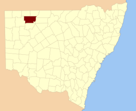
Ularara County NSW.
The climate is semi-arid, featuring low rainfall, very hot summer temperatures and cool nights in winter. [3] The parish has a Köppen climate classification of BWh (Hot desert)[4].
| Wanaaring | ||||||||||||||||||||||||||||||||||||||||||||||||||||||||||||
|---|---|---|---|---|---|---|---|---|---|---|---|---|---|---|---|---|---|---|---|---|---|---|---|---|---|---|---|---|---|---|---|---|---|---|---|---|---|---|---|---|---|---|---|---|---|---|---|---|---|---|---|---|---|---|---|---|---|---|---|---|
| Climate chart (explanation) | ||||||||||||||||||||||||||||||||||||||||||||||||||||||||||||
| ||||||||||||||||||||||||||||||||||||||||||||||||||||||||||||
| ||||||||||||||||||||||||||||||||||||||||||||||||||||||||||||
gollark: Huh, I thought you were going to complain about me "explaining closure terribly" or something.
gollark: It's called closure. Stuff defined in something gets access to locals from that thing.
gollark: Just do```luafunction fs.open(file, mode) local f = {} -- Store fs files in here local handle = io.open(file, mode) function f.readAll() return handle:read("*a") end function f.close() handle:close() end function f.write(data) handle:write(data) end return fend```unless there's some other thing you need it for.
gollark: Wait, why do you need a global `openFiles` thing for that?
gollark: Cool, should be useful.
References
- "Ularara". Geographical Names Register (GNR) of NSW. Geographical Names Board of New South Wales. Retrieved 11 August 2013.

- / Map of the County of Ularara, Western Division, Land Districts of Bourke (New South Wales. Department of Lands).
- BOM.
- Peel, M. C.; Finlayson, B. L.; McMahon, T. A. (2007). "Updated world map of the Köppen–Geiger climate classification". Hydrol. Earth Syst. Sci. 11: 1633–1644. doi:10.5194/hess-11-1633-2007. ISSN 1027-5606. (direct: Final Revised Paper)
This article is issued from Wikipedia. The text is licensed under Creative Commons - Attribution - Sharealike. Additional terms may apply for the media files.