Parish of Urilla
Urilla Parish located at 29.655278°S 143.068611°E is a cadastral parish of Ularara County New South Wales.[1][2]
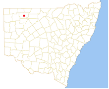
Location of the Parish
History
The Burke and Wills expedition were the first Europeans to the area, passing a few miles to the west.
Climate
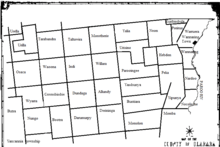
Map of Ularara County in North west New South Wales
The climate is semi-arid, featuring low rainfall, very hot summer temperatures and cool nights in winter.
[3] The parish has a Köppen climate classification of BWh (Hot desert)[4].
gollark: Well, yes, but on the other hand consumers don't seem to actually care much. Especially on phones.
gollark: They are part of the general trend away from general purpose computers, which I very much dislike.
gollark: It might have a dedicated management port, but otherwise probably anywhere it's connected; why would you *want* a hardware firewall thing, though?
gollark: I'd assume the law is more about intent there, though, i.e. are you trying to break into someone else's stuff.
gollark: It is? Weird.
References
- / Map of the County of Ularara, Western Division, Land Districts of Bourke (New South Wales. Department of Lands).
- "Ularara". Geographical Names Register (GNR) of NSW. Geographical Names Board of New South Wales. Retrieved 11 August 2013.

- BOM.
- Peel, M. C.; Finlayson, B. L.; McMahon, T. A. (2007). "Updated world map of the Köppen–Geiger climate classification". Hydrol. Earth Syst. Sci. 11: 1633–1644. doi:10.5194/hess-11-1633-2007. ISSN 1027-5606. (direct: Final Revised Paper)
This article is issued from Wikipedia. The text is licensed under Creative Commons - Attribution - Sharealike. Additional terms may apply for the media files.