Parish of Neon
Neon Parish, New South Wales is a rural locality and a cadastral parish of Ularara County New South Wales.[1][2]
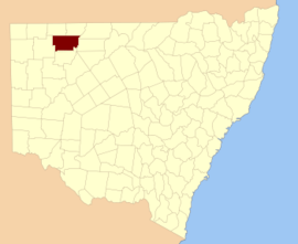
Ularara County NSW.
The parish is located at 29.39460°S 143.56040°E and sits on Possum Creek, a Tributary of the Paroo River. The climate is semi-arid, featuring low rainfall, very hot summer temperatures and cool nights in winter. [3]
History
The parish is on the traditional lands of the Paaruntyi people.
The Burke and Wills expedition were the first Europeans to the area, passing a few miles to the west.
Geography
The parish has a Köppen climate classification of BWh (Hot desert).[4]
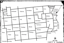
Map of Ularara County in North west New South Wales
gollark: ++delete communism
gollark: <:rustcode:747529842999689298>
gollark: <:bees:724389994663247974>
gollark: Good news, all apioentities of class φ and greater capable of interaction! My internet connection is back for some amount of time!
gollark: Well, see, it's spontaneously [REDACTED] critical subsystem apiofailure [BEES IN DATA].
References
- / Map of the County of Ularara, Western Division, Land Districts of Bourke (New South Wales. Department of Lands).
- "Ularara". Geographical Names Register (GNR) of NSW. Geographical Names Board of New South Wales. Retrieved 11 August 2013.

- BOM.
- Peel, M. C.; Finlayson, B. L.; McMahon, T. A. (2007). "Updated world map of the Köppen–Geiger climate classification". Hydrol. Earth Syst. Sci. 11: 1633–1644. doi:10.5194/hess-11-1633-2007. ISSN 1027-5606. (direct: Final Revised Paper)
This article is issued from Wikipedia. The text is licensed under Creative Commons - Attribution - Sharealike. Additional terms may apply for the media files.