Parish of Fulton
Fulton Parish in Mouramba County,[2] central New South Wales is a cadasteral parish of Australia.[3]
_New_South_Wales.png)
A map of Fulton Parish, New South Wales
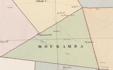
Map of Mouramba County (New South Wales) in 1886.[1]
Geography
Fulton Parish is in Cobar Shire at 32°10′48″S 145°29′13″E. The topography of the parish is generally flat with a thin scrub forest and the main economy of the parish is Agriculture. The Yethong Conservation Area is to the south of the parish and the nearest town is Nymagee, New South Wales.
gollark: Resolved now.
gollark: It was a spontaneous internal network misconfiguration.
gollark: <@!160279332454006795> It's not that. I fixed it.
gollark: I was only able to connect briefly over a horrible assemblage of SSH tunnels, but it seems like there's a port forwarding issue or I am suddenly behind CGNAT.
gollark: It's up over IPv6, so that's probably why there's confusion.
References
- from John Sands, Atlas of Australia 1886.
- "Mouramba County". Geographical Names Register (GNR) of NSW. Geographical Names Board of New South Wales.

- Map of the County of Mouramba, New South Wales. Department of Lands 1916.
This article is issued from Wikipedia. The text is licensed under Creative Commons - Attribution - Sharealike. Additional terms may apply for the media files.