Panarwa thikana
Panarwa was a thikana (vassal territory) in the former Mewar State in present-day Rajasthan, India. It was founded c. 1478 and lasted until its integration in the state of Rajasthan in 1949.
| Panarwa thikana पानरवा ठिकाना | |||||||
|---|---|---|---|---|---|---|---|
| Thikana of Mewar State | |||||||
| 1478–1949 | |||||||
 Coat of arms
| |||||||
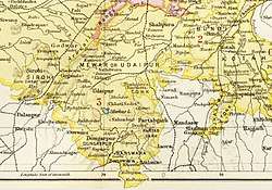
 Udaipur State in the Imperial Gazetteer of India | |||||||
| History | |||||||
• Established | 1478 | ||||||
• Independence of India | 1949 | ||||||
| |||||||
| Today part of | India | ||||||
| "Panarwa". Rajputana And Ajmer List Of Ruling Princes, Chiefs And Leading Personages (6th Edition). 1931. pp. 189–191. | |||||||
Geography
The Panarwa thikana was located in the Bhomat region in the former state of Mewar, in present-day Rajasthan.[1] The capital of the thikana was in the village of Manpur.[2] The territory of Panarwa was extensive until the 1700s, from Jura in the west to Pai in the east, gradually reducing in size as various smaller thikanas spun off its territory.[2] The thikanas of Ogna, Adivas, Umariya, Oda and others all claim Panarwa as their origin.[2]
At the time of accession to India in the 1949, Panarwa was bordered by the Jura thikana and to the west and northwest, Oghna thikana to the east and northeast, the Idar State to the south.[2] As of 1903, there were 60 villages in the thikana, and boasted two jagirs - Ora and Adiwas.[3]
History
Panarwa was originally ruled by bhil king , One of the famous bhil king named Rana Dayaldas[4] . The thikana was founded by Akshayraj a Solanki Rajput who took possession of Panarwa by attacking and killing Jivraj, a Jadu Rajput.[3] At some time in the 16th century, Harpal, then the ruler of Panarwa, served Udai Singh II, the ruler of Mewar, when the latter took refuge in the hills of Panarwa following an attack by Akbar.[5] In return, Udai Singh bestowed the title of 'Rana' on Harpal; the rulers of Panarwa carried the title since then.[5]. Harpal was a bhil king[6]. Harpal's grandson Punja was present with several hundred of his troops at the Battle of Haldighati in 1576; .[5]
Rulers of Panarwa
* Rana dayaldas
| List of Rulers |
* Akshayraj
|
References
- Imperial Gazetteer of India: Provincial Series Rajputana. Calcutta: Superintendent of Government Printing. 1908. pp. 138.
- Paliwal, Devilal (2000). पानरवा का सोलंकी राजवंश. Udaipur: Janak Prakashan. pp. 12–13.
- Chiefs And Leading Families In Rajputana. Calcutta: Office of the Superintendent of Government Printing. 1903. pp. 39-40.
- https://books.google.co.in/books?id=0bSmDwAAQBAJ&pg=PT51&lpg=PT51&dq=panarwa+bhil&source=bl&ots=zM574VuTmJ&sig=ACfU3U1jU6Y3NIyEHtzO2SYlBcV-KScV5g&hl=hi&sa=X&ved=2ahUKEwjJ2bzqs6jpAhXRmeYKHSqBB9gQ6AEwBXoECAUQAQ#v=onepage&q=panarwa%20bhil&f=false
- Rajputana And Ajmer List Of Ruling Princes, Chiefs And Leading Personages. Calcutta: Government of India Central Publication Branch. 1931. pp. 189–191.
- https://books.google.co.in/books?id=toZHAAAAMAAJ&q=Harpal+bhil&dq=Harpal+bhil&hl=hi&sa=X&ved=0ahUKEwiulMH4_rzpAhWZbysKHcTKDf4Q6AEIJjAA