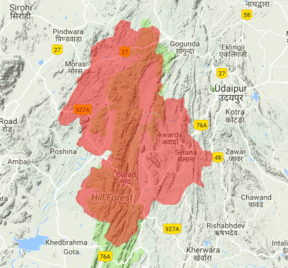
Bhomat
Bhomat (also referred to as Bhumat; Hindi: भोमट or भूमट) is a mountainous and forested area in southern Rajasthan, covering all or parts of the tehsils of Kotra, Jhadol and Kherwara in Udaipur district.[1] During British rule, the region was also referred to as 'Hilly Tracts of Mewar'.[2][3][4]
| Bhomat | |
|---|---|
| Bhumat (Hindi: भोमट or भूमट) | |
 The Bhomat region in southern Rajasthan | |
| Floor elevation | 800 ft (240 m) |
| Length | 94 km (58 mi) |
| Width | 56 km (35 mi) |
| Area | 1,233 km2 (476 sq mi) |
| Geology | |
| Type | Quartzite, Phyllite, Gneisses, Schist, Dolomitic marble |
| Geography | |
| Location | Rajasthan, India |
| Borders on | Girwa and Kherawa tehsils of Udaipur district (east), Gogunda tehsil of Udaipur district (north), Sirohi district (west), Gujarat (south) |
| Coordinates | 24°26′N 73°18′W |
| Traversed by | NH 76 |
| Rivers | Sabarmati River, Wakal River |
Name
The name 'Bhomat' is based on the understanding that land tenures known as bhum were held by jagirdars in the region.[2]
Geography
The Bhomat region is 25 to 50 kilometres (20 to 30 mi) wide in the east-west direction and stretches approximately 94 kilometres (58 mi) in the north-south axis. It covers approximately 1,233 square kilometres (476 sq mi).Geographically, Bhomat is divided in three sub-regions: its western area is called Bhader (Hindi: भाडेर), the central area is called Wakal (after the Wakal River; Hindi: वाकल) and the eastern area is called Khadak (Hindi: खड़क).[5] Primary rivers of the Bhomat are Sabarmati, Vakal, and Som.[5]
History
In the 15th century, Rana Kumbha is credited with building fortresses in the Bhomat region with the goal of containing revolts among the Bhils of the area.[6] In the 16th century, the Bhomat region was the shelter for the Ranas of Mewar when times of military crises caused by the Mughals.[7][8]
The Bhomat is recognized as a geographical or cultural region, but it was a unified political entity for only a short term - a century - under British paramountcy. Prior to accession of the Mewar State to the Republic of India in 1949, the region was ruled by several jagirdars, the important ones being: Jawas, Pahara, Madri, Thana, Chhani, Juda, Panarwa, Oghna, Umariya, Patia, Sarwan, and Nainbara.[2] These jagirdars were known as bhumias (i.e., ones holding a bhum land tenure) and owed only nominal allegiance to the Mewar State.[9]
For approximately a century during British paramountcy over Mewar State, the Bhomat represented a political unit divided in two sub-divisions - Kherwara Bhomat to the east and Kotra Bhomat to the east.[10]
Population
Adivasis comprise the majority of the population in the Bhomat.[2]
References
- Carstairs, G.M. (1961). Patterns of Religious Observance in Three Villages of Rajasthan in 'Aspects of Religion in Indian Society,’ edited by L.P. Vidyarthi. Meerut: Kedar Nath Ram Nath. pp. 59–113.
- Report on the Administration of Mewar State for Years 1940, 1941 and 1942. Mylapore: The Madras Law Journal Press. 1944. pp. 33–40.
- Bonarjee, P.D. (1899). A Handbook of the Fighting Races of India. Calcutta: Thacker, Spink & Co. p. 142.
- Fattori, Marco (2012). Gupta, Sanjukta Das; Basu, Raj Sekhar (eds.). The Bhil and the Rajput Kingdoms of Southern Rajasthan in Narratives from the Margins: Aspects of Adivasi History in India. Delhi: Primus Books. p. 134. ISBN 978-93-80607-10-8.
- Paliwal, Devilal (2000). पानरवा का सोलंकी राजवंश. Udaipur: Janak Prakashan.
- Kapur, Nandini Sinha (2002). State Formation in Rajasthan: Mewar During the Seventh-Fifteenth Centuries. New Delhi: Manohar. ISBN 81-7304-429-5.
- Sharma, G.N. (1951). Mewar and the Mughal Emperors (1526-1707 A.D.). Agra: Shiva Lal Agarwala & Co. Ltd. p. 170.
- Agarwal, B.D. Gazetteer of India: Rajasthan - Udaipur. Jaipur: Directorate of District Gazetteers, Government of Rajasthan. p. 46.
- Gupta, R.K.; Bakshi, S.R., eds. (2008). Rajasthan Through the Ages: Marwar and British Administration. New Delhi: Sarup & Sons. p. 70. ISBN 978-81-7625-841-8.
- Mewar History. Bombay: The Times of India Press. 1938. p. 50.