Palaw Township
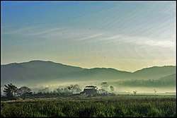
Palaw Township (Burmese: ပုလောမြို့နယ်) is a township of Myeik District in the Taninthayi Region of Burma (Myanmar). The principal town and administrative seat is Palaw. Second in importance is the town of Palauk.
Palaw Township | |
|---|---|
Township | |
 | |
 Palaw Township Location in Burma | |
| Coordinates: 13°07′N 98°41′E | |
| Country | |
| Region | Taninthayi |
| District | Myeik District |
| Capital | Palaw |
| Time zone | UTC+6.30 (MST) |
Administrative subdivisions
Palaw Township is divided into twenty-seven tracts. Six of those tracts are organized into the Palauk Subtownship which occupies the northern third of the township, and which is administered from the town of Palauk.[1]
|
|
|
Communities
Among the villages in Palaw Township are:[2] Banka, Bodaungseik, Kade, Kataungni, Mintein, Palawgong (Palawgon), Pidat, Tonbu, Wachaung, and Zadiwin.
There are a 50-bed township hospital, five 16-bed station hospitals at Pala, Palauk, Maligyun, Pyinbugyi and Kyaukka, one maternal and child health care centre, one urban health care centre, six rural health centers and 15 sub rural health care centers in 2011.[3]
References
- "Palaw Township, Tanintharyi, Myanmar" Archived 2011-07-22 at the Wayback Machine, Myanmar Information Management Unit (MIMU), 12 August 2010
- "Palaw Google Satellite Map" Palaw (Burma) gazetteer at Maplandia
- http://www.mrtv3.net.mm/newpaper/159newsn.pdf%5B%5D Page 11 Column 2
Capital: | |
|
Capital: Dawei | ||
| Dawei District |  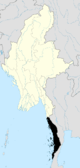 | |
| Kawthaung District |
| |
| Myeik District | ||
| Main cities and towns | ||