Pakipaki
Pakipaki is a village and rural community in the Hastings District and Hawke's Bay Region of New Zealand's North Island.
It is located at the intersection of State Highway 2 and State Highway 50A, south-west of Hastings and Havelock North.

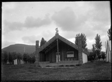
Houngarea meeting house near Pakipaki in the 1930s

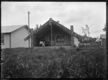
Mihiroa meeting house at Ngati Mihiroa Marae
The community has three Ngāti Kahungunu marae:
Education
Te Kura o Pakipaki is a co-educational state primary school,[3] with a roll of 33 as of March 2020.[4][5]
gollark: *still attempts to figure out ToD of siyat because for some mad reason DC won't provide it accurately*
gollark: ~~ridiculous~~
gollark: ~~can you not strikethrough emojis?!~~
gollark: ~~🌵~~
gollark: ~~yes, I think~~
References
- "Te Kāhui Māngai directory". tkm.govt.nz. Te Puni Kōkiri.
- "Māori Maps". maorimaps.com. Te Potiki National Trust.
- "Te Kura o Pakipaki Ministry of Education School Profile". educationcounts.govt.nz. Ministry of Education.
- "New Zealand Schools Directory". New Zealand Ministry of Education. Retrieved 26 April 2020.
- "Te Kura o Pakipaki Education Review Office Report". ero.govt.nz. Education Review Office.
This article is issued from Wikipedia. The text is licensed under Creative Commons - Attribution - Sharealike. Additional terms may apply for the media files.