Pacheco Creek (San Benito County)
Pacheco Creek is a 28 miles (45 km)[2] west by southwest flowing stream which heads in the Diablo Range in southeastern Santa Clara County and flows to San Felipe Lake,[3] the beginning of the Pajaro River mainstem, in San Benito County, California.
| Pacheco Creek | |
|---|---|
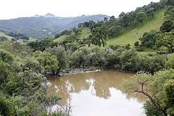 North Fork Pacheco Creek Dam just north of Highway 152, facing south, courtesy of Gary Reyes | |
| Location | |
| Country | United States |
| State | California |
| Region | San Benito and Santa Clara Counties, |
| Physical characteristics | |
| Source | Confluence of North Fork Pacheco Creek and South Fork Pacheco Creek |
| • location | Just south of Pacheco Reservoir, Santa Clara County |
| • coordinates | 37°02′42″N 121°17′23″W[1] |
| • elevation | 431 ft (131 m) |
| Mouth | San Felipe Lake and the source of the Pajaro River |
• location | 5 mi (8 km) east of Gilroy |
• coordinates | 36°58′38″N 121°27′37″W[1] |
• elevation | 144 ft (44 m) |
| Basin features | |
| Tributaries | |
| • left | South Fork Pacheco Creek, Tequisquita Slough |
| • right | North Fork Pacheco Creek, Cedar Creek (Pacheco Creek) |
History
The creek is named for Francisco Pacheco and Juan P. Pacheco who were granted the Rancho Ausaymas y San Felipe land grants in 1833 and 1836, and 1843 respectively. Francisco Pacheco came to California in 1819.[4] Just north of the earthen dam on North Fork Pacheco Creek was one of the last refuges of the Amah-Mutsun band of the Ohlone people, and is rich archeologically with multiple burial sites and artifacts, including projective points so large that they would have been used for bear or elk.[5] In 1993, Mark Hylkema documented eight different Native American sites in this area, dating from 1000 B.C. to 500 A.D.[6]
Watershed
The mainstem Pacheco Creek is formed by the confluence of the North Fork Pacheco Creek[9] and South Fork Pacheco Creek[10] about 7 miles (11 km) west of Pacheco Pass.[2] The creek generally follows Highway 152, passing from Santa Clara County to San Benito County, and continuing until it empties into San Felipe Lake, the source of the Pajaro River. The North Fork Pacheco Creek is a 19 miles (31 km) stream beginning in Henry W. Coe State Park at 2,360 feet (720 m) and receives the 6 miles (9.7 km) East Fork Pacheco Creek,[2][11] at Chimney Rock[12] before reaching Pacheco Reservoir, the latter just north of Highway 152 and the confluence of North and South Forks Pacheco Creek. The Mississippi Creek[13] tributary of North Fork Pacheco Creek is 9.5 miles (15.3 km) has an impoundment (Mississippi Lake) above 2,100 feet (640 m) elevation, and sources on Bear Mountain[14] on the northern side of Henry W. Coe State Park.
Just before joining Pacheco Creek above San Felipe (Soap) Lake, it is joined by Tequisquita Slough. The latter has 3 main tributaries, Santa Ana Creek,[15] Arroyo de Los Viboras, and Arroyo Dos Pichachos.[16] Santa Ana Creek is apparently named for the Rancho Santa Ana y Quien Sabe land grant.
Stream flow in Pacheco Creek is influenced by releases from the North Fork Pacheco Reservoir, which is operated by the Pacheco Pass Water District.[17]
Ecology
Significant remnants of the historic riparian California sycamore (Platanus racemosa) habitat still exists on Pacheco Creek and are a good example of the Central Coast Sycamore Alluvial Woodland habitat type.[18]
Pacheco Creek historically hosted steelhead trout (Oncorhynchus mykiss) as evidenced by a physical specimen collected in 1945 by D.H. Simpson in the California Academy of Sciences, "19.5 miles east of Gilroy on Hwy. 152".[19] Pacheco Reservoir (North Fork Dam) is an impassable barrier to in-migrating steelhead trout, preventing access to the nearly 34.5 miles (55.5 km) of stream consisting of North Fork Pacheco Creek, Mississippi Creek and East Fork Pacheco Creek.[2] In addition, resident rainbow (the landlocked form of steelhead trout) successfully rear in fast-water habitats grow rapidly and reach smolt size by the end of their first summer. In many years in late spring, prior to reservoir releases for agriculture, low stream flows and high water temperatures severely impact steelhead fry and small juveniles.[20] Other native fish in North Fork Pacheco Creek include Monterey sucker (Catostomus occidentalis mniotiltus) and Sacramento pikeminnow (Ptychocheilus grandis).[21]
See also
- Rivers of California
- Pacheco Creek (San Benito County), a tributary of the Pajaro River, in San Benito County, California.
- South Fork Pacheco Creek, a tributary stream of Pacheco Creek (San Benito County)
- East Fork Pacheco Creek, a tributary stream of Pacheco Creek (San Benito County)
- North Fork Pacheco Creek, a tributary stream of Pacheco Creek (San Benito County)
- Pacheco Reservoir, California, a reservoir formed by a dam on the north fork of Pacheco Creek (San Benito County) a.k.a. "North Fork Dam"
- Pacheco Creek (San Benito County), a tributary of the Pajaro River, in San Benito County, California.
References
- U.S. Geological Survey Geographic Names Information System: Pacheco Creek
- U.S. Geological Survey. National Hydrography Dataset high-resolution flowline data. The National Map, accessed February 6, 2016
- "San Felipe Lake". Geographic Names Information System. United States Geological Survey.
- E. G. Gudde, Bright, W. California Place Names: The Origin and Etymology of Current Geographic Names. Berkeley, California: University of California Press. p. 275. ISBN 9780520266193.CS1 maint: uses authors parameter (link)
- Lisa M. Krieger (August 16, 2017). "Pacheco Creek: Native American remains, artifacts found at proposed dam site". San Jose Mercury News. Retrieved August 18, 2017.
- Mark G. Hylkema (1993). "Some Perspective on Upland Settlement Patterns of the Central Diablo Range of California" (PDF). Proceedings of the Society for California Archaeology. 6: 99–119. Retrieved August 18, 2017.
- "Flooded California Residents Rescued as Major Storms Recede". ABC News. 12 January 2017. Retrieved 14 January 2017.
- "Health Officials Issue Tap Water Warning After Hollister Flooding". 12 January 2017. Retrieved 14 January 2017.
- "North Fork Pacheco Creek". Geographic Names Information System. United States Geological Survey.
- "South Fork Pacheco Creek". Geographic Names Information System. United States Geological Survey.
- "East Fork Pacheco Creek". Geographic Names Information System. United States Geological Survey.
- "Chimney Rock". Geographic Names Information System. United States Geological Survey.
- "Mississippi Creek". Geographic Names Information System. United States Geological Survey.
- "Bear Mountain". Geographic Names Information System. United States Geological Survey.
- "Santa Ana Creek". Geographic Names Information System. United States Geological Survey.
- Pacheco Watershed Working Group (2005). Pacheco Creek Agricultural Watershed Plan Annual Report (PDF) (Report). Archived from the original (PDF) on 2008-08-20. Retrieved 2012-12-02.
- Casagrande, Julie Renee (2010). Aquatic Ecology of San Felipe Lake, San Benito County, California. Master's Theses. Paper 3803 (Thesis). San Jose State University. Retrieved 2012-12-02.
- Grossinger, RM, EE Beller, MN Salomon, AA Whipple, RA Askevold, CJ Striplen, E Brewster, and RA Leidy (2008). South Santa Clara Valley Historical Ecology Study, including Soap Lake, the Upper Pajaro River, and Llagas, Uvas-Carnadero, and Pacheco Creek - A Report of SFEI’s Historical Ecology Program, SFEI Publication #558 (PDF) (Report). Oakland, California: San Francisco Estuary Institute. Retrieved 2012-12-02.CS1 maint: uses authors parameter (link)
- "CAS 19094 "Oncorhynchus mykiss gairdnerii"". California Academy of Sciences. 1945-11-12. Retrieved 2012-12-02.
- Jerry Smith (2007). Effects of Operation of Pacheco Reservoir on Steelhead (Report). San Jose State University. Retrieved 2016-02-07.
- "Fish Species by Location - 'Upper North Fork Pacheco Creek-180600020201'". University, Division of Agriculture and Natural Science. California Fish Website. Retrieved 2016-02-06.