Puerto Rico Highway 54
Puerto Rico Highway 54 (PR-54) is a short divided highway located in Guayama, Puerto Rico and is mainly a by-pass route from Puerto Rico Highway 3 out of Downtown Guayama to Puerto Rico Highway 53. The government of Puerto Rico named the stretch of highway that extends from PR-54, in Guayama, to PR-52, in Salinas Autopista José M. Dávila Monsanto in honor of the late Puerto Rican political leader José M. Dávila Monsanto.[2]
| ||||
|---|---|---|---|---|
| Avenida Pedro Albizu Campos | ||||
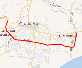
PR-54 highlighted in red | ||||
| Route information | ||||
| Maintained by Puerto Rico DTPW | ||||
| Length | 6.20 km[1] (3.85 mi) | |||
| Major junctions | ||||
| West end | ||||
| ||||
| East end | ||||
| Location | ||||
| Municipalities | Guayama | |||
| Highway system | ||||
| ||||

Major intersections
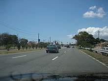
PR-54 allows people to access PR-3 from PR-53 without having to enter downtown Guayama
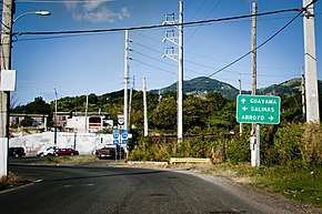
Approaching Highway 54 junction in Machete barrio, Guayama
The entire route is located in Guayama.
| Location | km[3] | mi | Destinations | Notes | |
|---|---|---|---|---|---|
| Palmas | 0.0 | 0.0 | Western terminus of PR-54 | ||
| Pozo Hondo | 0.6 | 0.37 | |||
| Guayama barrio-pueblo | 1.2 | 0.75 | |||
| 1.7 | 1.1 | Calle Arnaldo Bristol / Calle Paseo del Pueblo - Guayama | |||
| 2.2 | 1.4 | ||||
| 2.8 | 1.7 | ||||
| 3.7 | 2.3 | Avenida Periferal Sur - Guayama | |||
| Algarrobo | 5.1– 5.2 | 3.2– 3.2 | |||
| 6.20 | 3.85 | Eastern terminus of PR-54 | |||
1.000 mi = 1.609 km; 1.000 km = 0.621 mi
| |||||
gollark: Po.tato.
gollark: Also that the type of processing you want doesn't match with what happened during our evolution sometimes.
gollark: See, you have problems with local maxima.
gollark: Yes, it's not perfect.
gollark: Also, *why* would human brains be *optimal*?!
See also
References
- Puerto Rico Department of Transportation and Public Works. "Datos de Transito 2000-2009" (in Spanish). Retrieved 29 March 2019.
- "José M. Dávila Monsanto Toll Road (PR-53)" (Map). Wikimapia. Retrieved 1 June 2019.
- Google (28 February 2020). "PR-54" (Map). Google Maps. Google. Retrieved 28 February 2020.
This article is issued from Wikipedia. The text is licensed under Creative Commons - Attribution - Sharealike. Additional terms may apply for the media files.