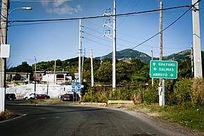
Puerto Rico Highway 744
Puerto Rico Highway 744 (PR-744) is a north–south road located entirely in the municipality of Guayama, Puerto Rico.[2] With a length of 2.7 kilometers (1.7 mi),[1] it begins at its intersection with PR-3 in downtown Guayama[3] and ends at Sector Central Machete in Machete barrio.[4]
| ||||
|---|---|---|---|---|
| Route information | ||||
| Maintained by Puerto Rico DTPW | ||||
| Length | 2.7 km[1] (1.7 mi) | |||
| Major junctions | ||||
| South end | Sector Central Machete in Machete | |||
| North end | ||||
| Location | ||||
| Municipalities | Guayama | |||
| Highway system | ||||
| ||||
Major intersections

PR-744 approaching PR-54 junction
The entire route is located in Guayama.
| Location | km[1] | mi | Destinations | Notes | |
|---|---|---|---|---|---|
| Machete | 2.7 | 1.7 | Sector Central Machete – Guayama | Southern terminus of PR-744 | |
| Guayama barrio-pueblo | 0.6 | 0.37 | |||
| 0.0 | 0.0 | Northern terminus of PR-744 | |||
| 1.000 mi = 1.609 km; 1.000 km = 0.621 mi | |||||
gollark: As it turns out, learning languages is hard, so they're subject to bad network effects.
gollark: I mean, you could presumably just speak another language slowly.
gollark: Interesting. I wonder why that is.
gollark: How do they break it more than every other language?
gollark: If you want maximum efficiency and have no concern for practical human use, just take English, run it through a good compression algorithm, and encode it as syllables somehow.
See also
References
- Google (14 August 2020). "PR-744" (Map). Google Maps. Google. Retrieved 14 August 2020.
- "Puerto Rico" (Map). National Geographic Adventure Map. 2011. ISBN 978-1566955188. Book 3107.
- "Tránsito Promedio Diario (AADT)". Transit Data (Datos de Tránsito) (in Spanish). Puerto Rico Department of Transportation and Public Works. p. 127. Retrieved 14 August 2020.
- "PR-744, Guayama, Puerto Rico". geoview.info. Retrieved 14 August 2020.
This article is issued from Wikipedia. The text is licensed under Creative Commons - Attribution - Sharealike. Additional terms may apply for the media files.

