Přílepy (Kroměříž District)
Přílepy (Czech pronunciation: [ˈpr̝̊iːlɛpɪ]) is a village and municipality (obec) in Kroměříž District in the Zlín Region of the Czech Republic.
Přílepy | |
|---|---|
Municipality | |
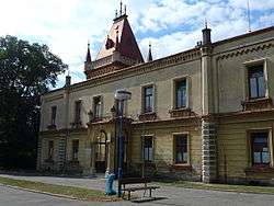 Castle in the village | |
_vlajka.jpg) Flag _znak.jpg) Coat of arms | |
 Přílepy | |
| Coordinates: 49°19′8″N 17°37′9″E | |
| Country | |
| Region | Zlín |
| District | Kroměříž |
| Area | |
| • Total | 3.17 km2 (1.22 sq mi) |
| Elevation | 297 m (974 ft) |
| Population (2019)[1] | |
| • Total | 984 |
| • Density | 310/km2 (800/sq mi) |
| Postal code | 769 01 |
| Website | http://www.prilepy.cz |
The municipality covers an area of 3.17 square kilometres (1.22 sq mi), and has a population of 984 (as of 2019).
Přílepy lies approximately 17 kilometres (11 mi) east of Kroměříž, 11 km (7 mi) north of Zlín, and 246 km (153 mi) east of Prague.
References
- "Population of municipalities of the Czech Republic". Czech Statistical Office. 1 January 2019.
| Wikimedia Commons has media related to Přílepy (Kroměříž District). |
This article is issued from Wikipedia. The text is licensed under Creative Commons - Attribution - Sharealike. Additional terms may apply for the media files.