Ozawkie Township, Jefferson County, Kansas
Ozawkie Township is a township in Jefferson County, Kansas, USA. As of the 2000 census, its population was 1,408.
Ozawkie Township | |
|---|---|
 Location in Jefferson County | |
| Coordinates: 39°15′35″N 95°25′51″W | |
| Country | United States |
| State | Kansas |
| County | Jefferson |
| Area | |
| • Total | 42.78 sq mi (110.79 km2) |
| • Land | 37.33 sq mi (96.68 km2) |
| • Water | 5.45 sq mi (14.11 km2) 12.74% |
| Elevation | 1,020 ft (311 m) |
| Population (2000) | |
| • Total | 1,408 |
| • Density | 37.7/sq mi (14.6/km2) |
| GNIS feature ID | 0478336 |
Geography
Ozawkie Township covers an area of 42.78 square miles (110.79 square kilometers); of this, 5.45 square miles (14.11 square kilometers) or 12.74 percent is water. The streams of Bowies Branch, Duck Creek, Fishpond Creek and French Creek run through this township.
Cities and towns
Unincorporated towns
- Indian Ridge
- Lake Shore
(This list is based on USGS data and may include former settlements.)
Adjacent townships
- Jefferson Township (northeast)
- Oskaloosa Township (east)
- Fairview Township (south)
- Rock Creek Township (west)
- Delaware Township (northwest)
Cemeteries
The township contains one cemetery, Fairview.
gollark: Luca_S: It's *probably* h4xxable.
gollark: LDD has Disknet, but I don't think it would work for that exact scenario.
gollark: I made LabelNet, for communication between adjacent computers by changing the label really fast.
gollark: There's actually software for... something like that?
gollark: "Perfect" is highly subjective.
References
External links
Municipalities and communities of Jefferson County, Kansas, United States | ||
|---|---|---|
| Cities | 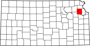 Map of Kansas highlighting Jefferson County | |
| CDP | ||
| Unincorporated communities | ||
| Townships | ||
| Authority control |
|
|---|
This article is issued from Wikipedia. The text is licensed under Creative Commons - Attribution - Sharealike. Additional terms may apply for the media files.