Otnice
Otnice is a village in the Vyškov District of the Czech Republic. It is located 20 km (12 mi) southeast of Brno and 11 km (6.8 mi) southwest of Slavkov u Brna. It has about 1,400 inhabitants.
Otnice | |
|---|---|
Village | |
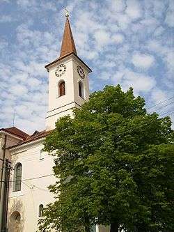 Roman Catholic church in Otnice | |
 Flag  Coat of arms | |
 Otnice Location in the Czech Republic | |
| Coordinates: 49°4′58″N 16°48′44″E | |
| Country | Czech Republic |
| Region | South Moravian |
| District | Vyškov |
| Municipality | Otnice |
| First mentioned | 1255 |
| Government | |
| • Mayor | Pavel Prokop |
| Area | |
| • Total | 8.7 km2 (3.4 sq mi) |
| Elevation | 216 m (709 ft) |
| Population (2008) | |
| • Total | 1,405 |
| • Density | 160/km2 (420/sq mi) |
| Time zone | UTC+1 (CET) |
| • Summer (DST) | UTC+2 (CEST) |
| Postal code | 683 54 |
| Website | www.otnice.cz |
Monuments
- Saint Aloysius Roman Catholic church
- Monument to fallen of World War I
- Monument to fallen of World War II
- Statue of saint John of Nepomuk
- Heart of Blessed Virgin Mary chapel
Local tourist attractions
- Brno (for example Špilberk Castle, St. Peter and Paul Cathedral, Villa Tugendhat)
- Slavkov u Brna
- The Battle of Austerlitz took place nearby.
gollark: <@480213740499894283> Why should they not be in the market?
gollark: If the messies reject each other, breed them to literally any other dragon and breed the child instead.
gollark: I've attempted to breed the 29G messy aeon (29G messy aeon. 29G messy aeon) with one of the "2Gs" but got no egg.
gollark: It would be a disservice to not use it correctly.
gollark: 29G. Messy. Aeon.
External links
- Village website
- Municipalities association Region Cezava
- Municipalities association Ždánický les - Politaví
| Wikimedia Commons has media related to Otnice. |
| Authority control |
|---|
This article is issued from Wikipedia. The text is licensed under Creative Commons - Attribution - Sharealike. Additional terms may apply for the media files.