Ostola
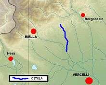
The Ostola is a 25 km long stream (torrente) in the Piedmont region of north-western Italy. It's a left side tributary of the Cervo which flows through the Province of Biella.
| Ostola | |
|---|---|
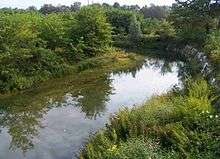
.jpg) The creek around Masserano | |
 Location within Biella | |
| Location | |
| Country | Italy |
| Physical characteristics | |
| Source | |
| • location | Monte Capoposto (Soprana) |
| • elevation | 600 m (2,000 ft) |
| Mouth | |
• location | Cervo near Castelletto Cervo |
• coordinates | 45°30′30″N 8°14′00″E |
| Length | 25.5 km (15.8 mi)[1] |
| Basin size | 65 km2 (25 sq mi)[2] |
| Discharge | |
| • average | 1.3 m3/s (46 cu ft/s)[3] |
| Basin features | |
| Progression | Cervo→ Sesia→ Po→ Adriatic Sea |
Geography

The Ostola source is on the southern slopes of Monte Capoposto (750 m), in the eastern and hilly part of the Alpi Biellesi, from which it flows through the communes of Soprana, Mezzana Mortigliengo and Casapinta. In the territory of Masserano it receives the waters of Torrente Cigliaga and is blocked by a dam forming the artificial lake "delle Piane". Flowing southwards the Ostola receives from the left side its mayor tributary, the Bisingana. It then enters the Po plain and near Castelletto Cervo it flows into the river Cervo.
See also
- Lago delle Piane
- Alpi Biellesi
References
- "Web-site of the river Po watershed Authority (Autorità di bacino del fiume Po)". Archived from the original on 2009-05-14. Retrieved 2013-01-30.
- AA.VV. (2004). "Elaborato I.c/5". Piano di Tutela delle Acque - Revisione del 1º luglio 2004; Caratterizzazione bacini Idrografici (PDF). Regione Piemonte. Archived from the original (PDF) on 2012-02-25. Retrieved 2013-01-28.
- AA.VV. (2004). "Elaborato I.c/7". Piano di Tutela delle Acque - Revisione del 1º luglio 2004; Caratterizzazione bacini Idrografici (PDF). Regione Piemonte. Archived from the original (PDF) on 2012-02-25. Retrieved 2013-01-28.
Other projects
![]()