Osage City Municipal Airport
Osage City Municipal Airport (FAA LID: 53K) is a city-owned public-use airport located one nautical mile (1.6 km) east of the central business district of Osage City, a city in Osage County, Kansas, United States.[1]
Osage City Municipal Airport | |||||||||||
|---|---|---|---|---|---|---|---|---|---|---|---|
 | |||||||||||
| Summary | |||||||||||
| Airport type | Public | ||||||||||
| Owner | City of Osage | ||||||||||
| Serves | Osage City, Kansas | ||||||||||
| Elevation AMSL | 1,105 ft / 337 m | ||||||||||
| Coordinates | 38°38′00″N 095°48′06″W | ||||||||||
| Runways | |||||||||||
| |||||||||||
| Statistics (2012) | |||||||||||
| |||||||||||
Facilities and aircraft
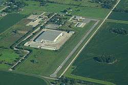
Osage City Municipal Airport covers an area of 20 acres (8.1 ha) at an elevation of 1105 feet (337 m) above mean sea level. It has one runway: 17/35 is 2,560 by 40 feet (780 x 12 m) with an asphalt surface.[1]
For the 12-month period ending August 31, 2012, the airport had 2,700 aircraft operations, an average of 7 per day: 100% general aviation. At that time there were 17 aircraft based at this airport: 71% single-engine and 29% helicopter.[1]
gollark: Don't use that. It makes them host HTTP for your domain and send 301 redirects to somewhere else.
gollark: - good contextual backlinks- small code base, can actually be read, also lightweight- simple Markdown support instead of horrible, *horrible* custom wikitext implementation- cooler login page- single user design
gollark: It's good because it has cool features, not too much code, and a fairly nice UI.
gollark: Failure to justify opinion → absolutely wrong in all ways → Minoteaur best wiki-styled vaguely graph-structured server-rendered Nim-based note-taking application.
gollark: Why?
References
- FAA Airport Master Record for 53K (Form 5010 PDF), effective 2013-08-22.
External links
- Osage City Municipal Airport (53K) at Kansas DOT Airport Directory
- Aerial image as of October 1991 from USGS The National Map
- FAA Terminal Procedures for 53K, effective August 13, 2020
- Resources for this airport:
- FAA airport information for 53K
- AirNav airport information for 53K
- FlightAware airport information and live flight tracker
- SkyVector aeronautical chart for 53K
This article is issued from Wikipedia. The text is licensed under Creative Commons - Attribution - Sharealike. Additional terms may apply for the media files.