Orfani
Orfani (Turkish: Örfihane,Greek: Ορφάνι, formerly Ορφάνιον - Orfanion) is a village and a former municipality in the Kavala regional unit, East Macedonia and Thrace, Greece. Since the 2011 local government reform it is part of the municipality Pangaio, of which it is a municipal unit[2] (municipal unit of Orfano[3]). The municipal unit has an area of 200.862 km2.[4] The municipal unit has a population of 5,249, and the village of Orfani has 706 inhabitants (2011).[1] The seat of the municipality was Galipsos.
Orfani Ορφάνι | |
|---|---|
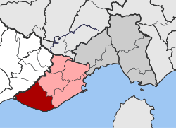
 Orfani Location within the regional unit  | |
| Coordinates: 40°47′N 23°57′E | |
| Country | Greece |
| Administrative region | East Macedonia and Thrace |
| Regional unit | Kavala |
| Municipality | Pangaio |
| • Municipal unit | 200.9 km2 (77.6 sq mi) |
| Population (2011)[1] | |
| • Municipal unit | 5,249 |
| • Municipal unit density | 26/km2 (68/sq mi) |
| Community | |
| • Population | 706 (2011) |
| Time zone | UTC+2 (EET) |
| • Summer (DST) | UTC+3 (EEST) |
| Vehicle registration | ΚΒ |
Called Orfano in the 19th century, the town has been identified with the Byzantine Chrysopolis in Macedonia.[5][6]
References
- "Απογραφή Πληθυσμού - Κατοικιών 2011. ΜΟΝΙΜΟΣ Πληθυσμός" (in Greek). Hellenic Statistical Authority.
- Kallikratis law Greece Ministry of Interior (in Greek)
- De Jure (in English). Hellenic Statistical Authority
- "Population & housing census 2001 (incl. area and average elevation)" (PDF) (in Greek). National Statistical Service of Greece.
- A. Brückner et al., Archiv für Slavische Mitwirkung, 17. Band (1895), "an der Küste Ghrysopolis (Grisopoli der ital. Seekarten), das jetzige Orfano"
- Joachim Lelewel, Géographie du Moyen Âge, tomes III et IV (Bruxelles 1852), "la maritime Χρυσόπολις, Grisopoli, ville d'or, à laquelle les Latins donnèrent le nom de Conlessa, laquelle, déplacée par différents désastres, conserve son nom dans Orfano"
This article is issued from Wikipedia. The text is licensed under Creative Commons - Attribution - Sharealike. Additional terms may apply for the media files.