Orchard, Colorado
Orchard is an unincorporated community and a U.S. Post Office in Morgan County, Colorado, United States. The Orchard Post Office has the ZIP Code 80649.[2]
Orchard, Colorado | |
|---|---|
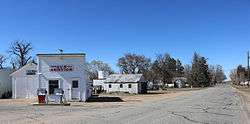 Washington Avenue in Orchard, Colorado. | |
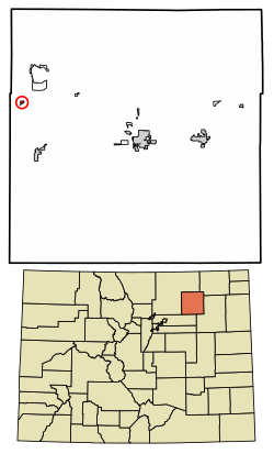 Location of Orchard in Morgan County, Colorado. | |
 Location in Morgan County and the state of Colorado  Orchard, Colorado (the United States) | |
| Coordinates: 40°19′51″N 104°07′07″W | |
| Country | |
| State | |
| Counties | Morgan[1] |
| Elevation | 4,413 ft (1,345 m) |
| Time zone | UTC-7 (MST) |
| • Summer (DST) | UTC-6 (MDT) |
| ZIP code[2] | 80649 |
| GNIS feature ID | 0180764 |
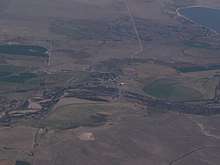
Oblique air photo of Orchard (center) with the South Platte River crossing from left to right, in September 2018
A post office called Orchard has been in operation since 1882.[3] The community was named for a grove of cottonwood trees near the original town site.[4]
Geography
Orchard is located at 40°19′51″N 104°07′07″W (40.330843,-104.118633).
Orchard is the town that was used to film James Michener's miniseries Centennial. Most if not all of the remnants of the production sets are now gone.
Demographics
| Historical population | |||
|---|---|---|---|
| Census | Pop. | %± | |
| U.S. Decennial Census[5] | |||
gollark: We configured that across APIONET.
gollark: 16.
gollark: Ugh, fiiiine, send more if you want.
gollark: Well, we obliterated all nearby LyricTech™ forces trivially, which I think counts?
gollark: ApioServ can already:- securely authenticate me and operatorize me- allow me to inject arbitrary IRC commands, for security- list nicks and channels it sees
See also
- Outline of Colorado
- State of Colorado
- Colorado cities and towns
- Colorado census designated places
- Colorado counties
- Colorado metropolitan areas
- Fort Morgan, CO Micropolitan Statistical Area
- Colorado cities and towns
References
- "US Board on Geographic Names". United States Geological Survey. 2007-10-25. Retrieved 2008-01-31.
- "ZIP Code Lookup". United States Postal Service. January 2, 2007. Archived from the original (JavaScript/HTML) on January 1, 2008. Retrieved January 2, 2007.
- "Post offices". Jim Forte Postal History. Retrieved 6 July 2016.
- Dawson, John Frank. Place names in Colorado: why 700 communities were so named, 150 of Spanish or Indian origin. Denver, CO: The J. Frank Dawson Publishing Co. p. 38.
- "Census of Population and Housing". Census.gov. Retrieved June 4, 2016.
Municipalities and communities of Morgan County, Colorado, United States | ||
|---|---|---|
| Cities | 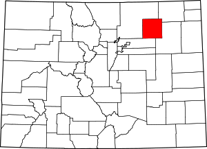 Map of Colorado highlighting Morgan County | |
| Towns | ||
| CDPs | ||
| Unincorporated community | ||
| Ghost towns | ||
| Authority control |
|
|---|
This article is issued from Wikipedia. The text is licensed under Creative Commons - Attribution - Sharealike. Additional terms may apply for the media files.