Omiroupoli
Omiroupoli (Greek: Ομηρούπολη) is a former municipality in the central part of on the island of Chios, North Aegean, Greece. Since the 2011 local government reform it is part of the municipality Chios, of which it is a municipal unit.[2] The municipal unit has an area of 155.015 km2.[3] Population 7,527 people (2011 census). The seat of the municipality was Vrontados (pop. 5,323), the second largest town on the island (after Chios (town)). The next largest towns are Lagkáda (760), Karyaí (618), and Sykiáda (562).
Omiroupoli Ομηρούπολη | |
|---|---|
 Omiroupoli Location within the regional unit 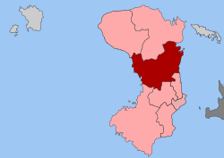 | |
| Coordinates: 38°24′N 26°7′E | |
| Country | Greece |
| Administrative region | North Aegean |
| Regional unit | Chios |
| Municipality | Chios |
| • Municipal unit | 155.015 km2 (59.852 sq mi) |
| Elevation | 40 m (130 ft) |
| Population (2011)[1] | |
| • Municipal unit | 7,527 |
| • Municipal unit density | 49/km2 (130/sq mi) |
| Time zone | UTC+2 (EET) |
| • Summer (DST) | UTC+3 (EEST) |
| Postal code | 822 00 |
| Area code(s) | 22710 |
| Vehicle registration | ΧΙ |
| Website | www.homeroupolis.gr |
Tradition claims that epic poet Homer (Όμηρος) was born and lived here, thus the name of the municipal unit.
Historical population
| Year | Population |
|---|---|
| 1991 | 7,477 |
| 2001 | 7,335 |
| 2011 | 7,527 |
gollark: What would be so hilarious about both of us doing security for Keansia?
gollark: PotatOS computers are harmless.
gollark: Keanu, I think the best way to do enforcement would be one traffic turtle per government building.
gollark: I get the lasers much cheaper than market price by going to kepler's blaze farm then lemmmy, at least.
gollark: Admittedly the traffic turtles *are* really expensive (30KST laser+ ~5KST entity sensor + ~5KST turtle).
References
- "Απογραφή Πληθυσμού - Κατοικιών 2011. ΜΟΝΙΜΟΣ Πληθυσμός" (in Greek). Hellenic Statistical Authority.
- Kallikratis law Greece Ministry of Interior (in Greek)
- "Population & housing census 2001 (incl. area and average elevation)" (PDF) (in Greek). National Statistical Service of Greece.
This article is issued from Wikipedia. The text is licensed under Creative Commons - Attribution - Sharealike. Additional terms may apply for the media files.